
On Sunday afternoon September 1, 2002 I had an experience I never thought possible in this county. I went out near Springer to Magnetic Hill and watched my truck roll uphill at 10 miles an hour!
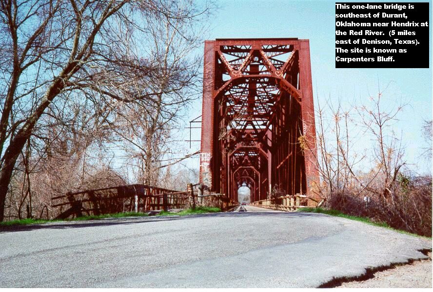
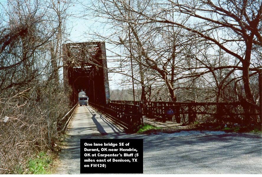
Southeast of Durant, Oklahoma near Hendrix, Oklahoma is an old one lane bridge. I believe it was built before statehood (1907). The old iron bridge allows crossing between Oklahoma and Texas. The area is called Carpenters Bluff. Carpenters Bluff is 5 miles east of Denison, Texas on FM120. This is the bridge looking south toward Texas . And this is looking north from the Texas side toward Oklahoma.
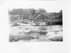
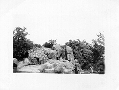
My friends Leroy and Jimmie McDaniel of Mannsville, Oklahoma furnished the following four photos of Devil’s Den. Devil’s Den was a picnic and swimming area located about 3 miles north of Tishomingo, Oklahoma. The recreation area was closed down around 1980. Photo number one, photo number two photo number three, and photo number four . These photos were taken around 1950.
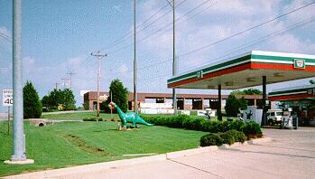
Dino the Dinosaur has been around 10 Million years. Lately he’s been living at the Sinclair Station at West Broadway and South Rockford Road. Dino just hangs out around the curb there. The Department of Transporation and the City of Ardmore told him in 1993 he had to move back into his own yard. Not being the average dinosaur (millions of years of knowledge packed in that pea brain of his), he decided to go to court and fight back. A district judge ruled Dino did not have to move back from the curb. Needless to say, Dino is happy now.
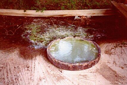
How about a long time Carter county secret? You don’t have to go to Sulphur, Oklahoma to find sulphur water. Just go west of I-35 and Highway 53W for about 6 miles to Woodford, then turn north for about ½ mile and you find a sulphur artesian well beside the road. Here is a closeup of the rotten egg smelling water bubbling up out of the ground. On July 16, 1997 we had the water tested by the Oklahoma Department of Environmental Quality and tested positive for one or more coliform organisms. So, I sure wouldn’t drink that water for love nor money.
Old Relay Station located 8 miles south of Sulphur, Oklahoma on Highway 177. This old building was where they kept a fresh horse ready for the pony express rider, on his mail delivery route.
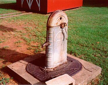
Here’s an old hand-driven water pump located behind a residence in Chickasha, Oklahoma.
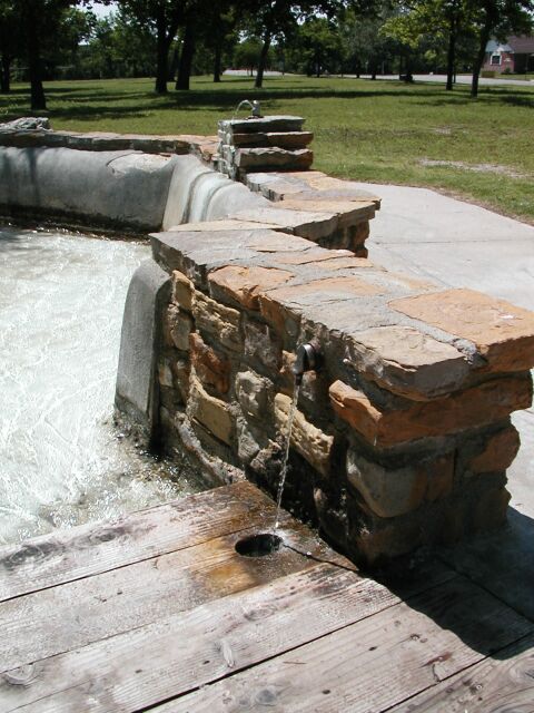
The Vendome Well located in Sulphur, Oklahoma near the north entrance to the Chickasaw National Recreation Park. This water shoots up out of the ground and Indians many, many years ago said it has medicinal qualities. I know of people driving 100 miles each weekend, filling up plastic trash barrels, and taking the water home with them. Once you get used to that sulphur (rotten egg) taste and smell, it ain’t that bad. Care for a drink?
Photo 1
Photo 2
Photo 3
Photo 4
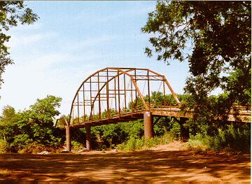
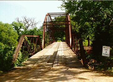
Photo 5Here’s a side view of the old Norton Bridge north of Mannsville, Oklahoma over Washita River. And here is a closer view looking northward through the bridge. Notice the sign that reads “Weight Limit 3 Tons.” Here is a map on how to find Norton Bridge map .
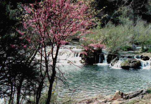
Turner Falls is so beautiful tucked away in the Arbuckle Mountains, just 18 miles north of Ardmore. It is truely a breath-taking scene, to look down from Highway 77 toward the falls, far below. This is a “Must See” in Southern Oklahoma.
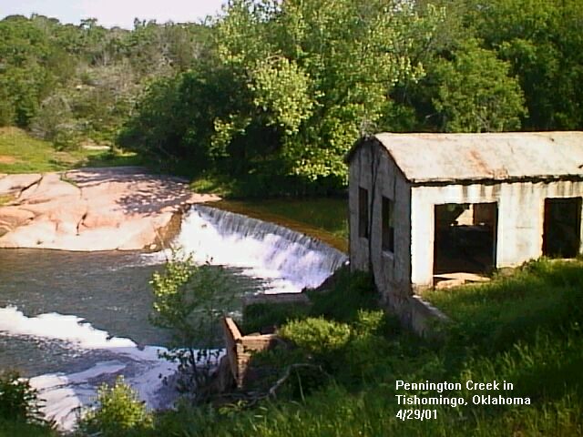
This is a beautiful 1996 photo of the Pennington Creek swimming hole and dam at Tishomingo, Oklahoma. It is located just a couple of blocks north of the highway in Tishomingo. Here is another view, just as little closer up I took in 2001.
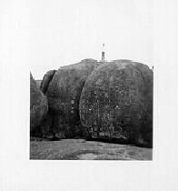
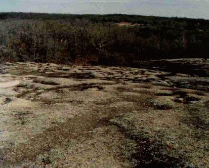
Ten Acre Rock is located just a few miles north of Ravia, Oklahoma on Highway 1. It is said, the granite at the State Capital all came from Ten Acre Rock. People used to go there years ago and picnic. Even though it is on private property, people still go there for the day, and picnic.
This is Slippery Falls Located at the Boys Scout Ranch near Tishomingo.
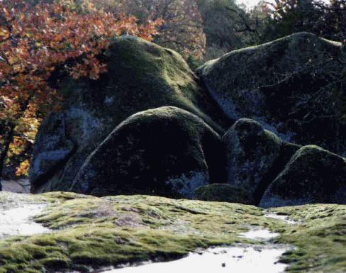
This is just a glimpse of the huge rocks near Larry and Debbie Boston’s property. Very magnificent! The Boston’s have been so helpful and sending pictures of interesting sites around Tishomingo.
I remember when a kid, and in the Boy Scouts, we used to go out on 3rd Northeast just before you get to Dogwood Road on the north side of the 3rd and spend the day at Sand Canyon. The last time I was out there, erosion had pretty much ruined the beauty of Sand Canyon. Sand Canyon is on private property.
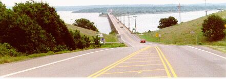
Here’s a view of Roosevelt Bridge where it crosses Lake Texhoma, looking east toward Durant, Oklahoma. And here’s the “welcome” sign at the entrance to Lake Texhoma Lodge just west of Roosevelt Bridge.
Old Washington Elementary School at Martin Luther King Drive and “G” Northeast (later named the Early Childhood Center). The school burned and no longer exists.
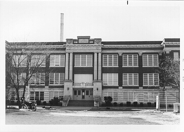
Old Ardmore Junior High which was located at A street NW and 2nd (which has since been torn down)
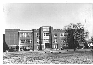
Old Ardmore High School, located at North Washington and 2rd Street
Old Carnegie Library located at Stanley and “E” Street Southwest (now called the Ardmore Garden Center)
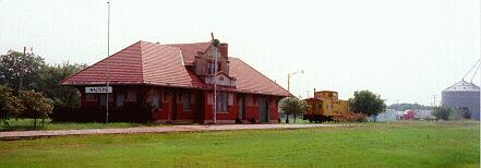
This isn’t quite in central Oklahoma, but it was such a unique picture, I couldn’t resist. It’s a photo of the Walters, Oklahoma train depot . Walters is southeast of Lawton. One thing that makes it unique is the caboose at the right. Seems like cabooses are almost a thing of the past.
This is a photo of the old bridge north of Gainesville, Texas that crossed the Red River into Oklahoma. The automobile is about a 1930 model… so we assume the photo was taken about that time.
This is a photo of an old Dempster Mill Mfg water pump. The Dempster company was located in Beatrice, Nebraska. This particular pump is located S.E. of Lake Murray a few miles, south of Mom & Pops Grocery in the small community of Ran, Oklahoma. About the only thing still there in Ran is this water pump and an old building where the Bethel Union Baptist Church meets. This is an April 1998 photo.
This is a photo of the old Santa Fe steam locomotive located in Pauls Valley, Oklahoma.
I happen to have an Ardmore, Oklahoma telephone book that was owned by my mother. It was printed in August 1937. It is only about 30 pages in length including a yellow pages section. Some of the phone numbers are very unusual. They are the listings of people out in the country, for instance, W.C. Wright NW of City 9515-F-2 Mr. Wright was the father of a friend of mine in town, W.C. Wright, Jr., we call him Cliff (he’s an accountant). Then there’s Stroman Motors 224 West Main who’s phone number was 445. Ray’s Office Supply 15 A SW phone 387. If you wanted the police department you asked the Operator for 248. For fire, just ask the Operator for “Fire Department”.
The yellow pages has some unusual listings too. For instance, under Torpedoes there is American Glycerin Co., 224 11th NW and American Torpedo Co. 224 11th NW (same address). And Haberdashers – See Men’s Furnishings. But they did have one thing I like in 1937, BBQ at the Green Frog Sandwich Shop 511 West Main. Think I’ll call them at 66 and place an order for some sliced beef!
I remember when I was about 12 years old, Ardmore switching from the Operator assisted calls to the rotary dial. Guess that was around the early 1960s? They installed our rotary phone a year in advance, then on a Sunday morning at 6am we finally got to try it. I set my alarm clock for 6am and got up, and called the Time and Temperature. No Operator was needed… you just used your finger to dial a number…… amazing.
This is a picture of the front cover of the 1937 phone book
And here is the inside cover with the phone pricing information
Between the years of 1914 and 1917 there were several public drawings held in Oklahoma for land on Indian reservations. This photo is owned by Ann Randolph here in Ardmore, Oklahoma. Many will remember Ann from here work here at the Ardmore OSU Extension Office.
This is a photo of a parade in Cordell, Oklahoma in 1924. The original photo is owned by Ann Randolph of Ardmore, Oklahoma.
As a teen back in the 1960s about the only place in Ardmore to get the latest Rock & Roll releases was Luke’s Music Store at 212 West Main. In high school as we listened to Rock & Roll, we knew that each Wednesday afternoon around 3 or 4pm, we could rush down to Luke’s and buy the latest songs. That is the time the postman delivered the box of new releases. I remember in the 9th grade this girl brought to class a Life Magazine. On it’s cover was the Beatles. Until that day, none of us here in Ardmore had any idea who the Beatles were. Little did we know that a year later they would take this country by storm, becoming the greatest Rock & Roll group in the history of the world. I remember waiting each Sunday night to watch Ed Sullivan and his “really big show” on tv just to see the hottest Rock & Roll stars. There was no cable tv and my family only had an outside antenna, I would get so mad when the picture would fade out and become snowy, just as the guest singers would come on. After school we would listen to our favorite Rock & Roll radio station, KOMA in Oklahoma City. KOMA is still playing those oldies. If you have RealAudio on your computer, you can listen to KOMA by going to the KOMA website and click on the “jukebox”, and you’ll hear KOMA live radio broadcast.
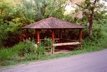
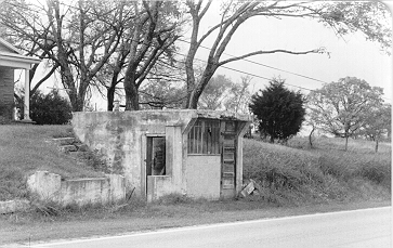
About 30 miles northeast of Ardmore is Sulphur, Oklahoma. Many people have driven south on Highway 177 through the years. About 4 miles south of Sulphur on the west side of the highway, is this little concrete structure, kinda tucked halfway into the hillside. Few travelers, passing by this little building, realize it played an important part of Oklahoma’s past. This little, almost obscure building in the hillside was used stagecoach stop for changing out a fresh team of horses. The stagecoach stop was built in the 1880s/1890s. When I took this picture about 28 years ago, there was a home in the background. Today that home is no longer there, and only trees and a hill are seen. But the little concrete building is still standing… barely, as a reminder of yesteryear. This is the black and white photo I took using a Kodak 35mm camera in the early 1970s.
In the late evening hours of Friday, September 16, 1910 the city of Springer, Oklahoma came close to becoming history, as a fire nearly engulfed the city. Had firefighters not resorted to the use of dynamite to stop the fire, the entire city may have been destroyed.
Cole Younger was an outlaw and even a member of the Quantrill’s Raiders during the Civil War. Ardmoreite Kenneth Keith’s Great Grandfather lived in Madill, Indian Territory (Oklahoma). His Great Grandfather, George Washington Riggs, posed for a photo in 1906 at Madill with his friend Cole Younger. This is the photo Ken gave me for scanning of his Great Grandfather and Cole Younger . Learn more about Cole Younger and his brothers, read their bibliographies . The Quantrill Raiders were a band of no more then a dozen Confederate sympathizers, conducting raids against the Union Army of the North during the Civil War years.
When I was about 8 or 10 years old, I remember my grandfather, Stanley Carmon, taking me to the Ardmore Hotel on main street. The building was remodeled into the present day Lincoln Center. The one thing I remember when visiting the Ardmore Hotel was the TV in the lobby. We did not even have a TV at that time.
Back in the 50’s and 60’s I remember going to get dipped ice cream on West Broadway and K street at Tom Cooper Farms. This photo was taken about 1954.
How about those crazy little jokes we used to play on people when we were kids? Remember the one where you called some corner grocery store and asked, “Do you have Prince Albert in the can?” When the store owner replies, “yes,” we would then say, “Well, you better let Prince Albert out!” and then promptly hung up.
Here’s a old .29 cent can of Renuzit Spot Cleaner ( 4 fluid ozs) I own. And this is the backside of the can. It was made by Renuzit Home Produces of Philadelphia, PA before zipcodes. It has the “Guaranteed by Good Housekeeping” seal on the front. I guess products aren’t guaranteed like that anymore. Seems like guarantees are about to be a thing of the past, if not already.
Remember your great grandmother dipping snuff? Here is my great grandmother’s W.E. Garrett & Sons snuff. The larger one is what we called a “glimpsepast/snuff glass” jar and the smaller is the little tin of snuff. Both are unopened and full of snuff. My great grandmother Ida Miller lived across the street east of Washington School and she died February 28, 1965. I’ve had the snuff since 1965.
This is a can of Casco Powered Casein Glue made by the Borden Company of New York. I own a smaller 1.5 ounce can and an 8 ounce size which makes 1½ pints of liquid glue. Both are amost full of powder.
Remember in art class using those India ink pens, the kind you dipped in the bottle of India ink? Here is a bottle of Pelican Drawing Ink I own. I obtained it about 1960, and I know it’s a lot older then that.
This is a photo of the old Ford model T condenser coil I own. When I was a teen, my neighbor used it to shock people on Halloween. I’ve even heard they used them to shock fish to the surface.
Back during World War II certain items were scare. The government issued “war stamps” which the people could use to purchase these rationed items. I had one friend who said he was only allowed a few gallons of gasoline a month. Anyway, here is my mother’s “ration book”. My father had his own. They were issued in 1942. This is the “ front of the booklet and this is the back page of the booklet. These are the actual stamps inside which were perforated for tearing.
Ten Acre Rock is located just a few miles north of Ravia, Oklahoma on Highway 1. It is said, the granite at the State Capital all came from Ten Acre Rock. People used to go there years ago and picnic. Even though it is on private property, people still go there for the day, and to picnic.
This is the old swinging bridge that was in Tishomingo, Oklahoma. I remember going over it in the early 1970’s and using my car to “rock” the bridge back and forth. It has since been replaced with a concrete bridge.
The following are some kind of “old stamps” before 1907 when Oklahoma was called Indian Territory (I.T.). This is a “stamp” depicting the railroad depot in Mannsville, Oklahoma. This one is of the Mannsville First National Bank building. This one shows the old Argo Hotel in Mannsville. And this one is the First Baptist Church in Mannsville, Oklahoma. All these “stamp pics” were provided to me by Leroy and Jimmie McDaniel of Ardmore. If any one knows just what these “picture stamps” are, please let us hear from you.
I guess Memorial Hospital in Ardmore is now a thing of the past, at least in name, since it is now called Mercy Memorial Hospital. This is a “coaster” the hospital produced in 1975 that a lady gave me. The six people on the coaster are all friends of mine. Several have passed away. They are top, Woodie Scott and Gwen Sutton; middle, Margorie Whipple and Jean Wages; bottom, Clifford McIntosh and Bill Ford.
This is a photo of a horse and enclosed buggy which I took in December 1996 at an Amish community about 5 miles north of Wapanucka, Oklahoma. Their beliefs do not allow a picture taken of them, but they did allow me to take one of their horse and buggy tied up out front of their general store. Another 5 miles north of where I took this photo is Clarita, Oklahoma, also an Amish settlement.
Leroy McDaniel of Ardmore took the following photos when he was around 16 years old (about 1943). The photos are of the cotton gin fire in Ardmore located on the east side of South Washington in the 300 block. Photo one, photo two, photo three, photo four, photo five, and photo six.
This is an old gasoline filling station located 9 miles north of Tishomingo, Oklahoma at the intersection of Highway 99 and Highway 7. The front, as you can see, is the original log cabin building. A man who was around 10 years old in 1930 told me he and his dad used to stop at this station and get gasoline. They would pump the gas up into the glass bowl and then let it drain into the car’s gas tank. Also note the old windmill behind the house.
“Doodle bug doodle bug house on fire…..” Remember how we used to stir the twig around and around in the doodle bug home, trying to get him out? I discovered these doodle bugs in my neighbors backyard. Doesn’t seem to be many doodle bugs around here anymore. Could they be an endangered species like the horny toad?
Remember when we used to go on a real dark night to visit Mr. Apple and Mr. Johnson ? Took a brave fool to walk up to those doors, knock, and ask, “Is anyone home?”
Here is a set of beautiful and very old playing cards I own.
Remember when we used to have Horny Toads in southern Oklahoma? I used to catch them in my yard as a kid. I guess that is a thing of the past. I haven’t seen one in over 20 years. If you know of any in our area, let me know. UPDATE: August 1997. Here is a pic of a horny toad a friend of mine took in the school yard at the old Dunbar School at G S.E. and White Street. She took a photo of it to show me there are still some alive in Carter county, but very few, not like it used to be.
Here are several counter checks and receipts written before 1900 and shortly thereafter. Counter checks were just a pad of blank checks kept at the banks and used by everyone for writing checks back in those days.
The old 700 Ranch House before restoration. This house was located in the vicinity of “G” Street Southeast before being moved in front of the Hardy Murphy Coliseum. This picture was taken in 1950. It now stands at the Carter County Museum.
The old Von Keller Hospital (1919 picture) which was located just southwest a few feet from the present Seventh Day Adventist Hospital (now called Memorial Hospital South Campus). Dr. Frederick Von Keller (1900 picture) was the Founder of the hospital. The hospital building was torn down around 1971.
The old Hardy Sanitarium, located at “B” Street SW and 1st where the post office now stands – circa 1911. It’s founder was Dr. Walter Hardy – circa 1940.
When I was born at the Hardy Sanitarium in 1949 , here is what it looked like at that time.
Mason’s building at Main and North Washington. Circa 1905 (before statehood).
Here is the old prairie steamer located in front of the Hardy Murphy Coliseum in Ardmore. The locomotive was used to bring doctors and nurses to Ardmore during the “great explosion”.
The Ardmore Osteopathic Hospital located at 823 Isabel. The hospital was closed down around 1972. (1950 photo)
This big dirt mound at Norman, Oklahoma at I-35 and Robinson and was used during World War II for artillery target practice. It was known as Mount Williams. I took the photo in 1974 with a Kodak 35mm camera. Wikipedia Info
A favorite for young and old alike, was the old Miller’s Dairy Freeze, located in the northeast corner of West Broadway and “E” Street NW. It was owned by Ernie and Fran Miller. (1974 photo)
Dr. J. Jay Boyd, (1875-1974) the “sugar pill” doctor. Dr. Boyd was nationally known for his Poison Ivy medication. I remember in the ’60s going to see him at his office located at 127 “F” Street NE. (1966 photo)
In the early morning hours of April 19, 1909 in Ada, Oklahoma, a mob of 200 men took four prisoners from jail and lynched them in a nearby stable. This is an acutual photo taken of the hanging that morning in 1909.
Buck Garrett was probably the most famous sheriff of Carter county. He and his chief deputy, Bud Ballew, were know throughout Oklahoma on their efforts to fight crime during the oil boom years. Buck Garrett is buried in Rosehill Cemetery in Ardmore. Bud Ballew is buried in the Lone Grove cemetery just north of the gate.
In 1925 Sheriff Ewing London was removed from office by a district judge. County Commissioners appointed Ardmore dairyman Jim Cruce as the new sheriff . Cruce would only be sheriff for 30 days.
In 1911 Ardmore Police Chief Buck Garrett decided to run for sheriff. At the December 1911 commission meeting, Garrett resigned, and city commissioners appointed Smith Redmon as the new police chief.
Ardmore Oil Baron is shot and dies in the midst of a love scandal that’s surrounded by mystery and unanswered questions. (1910 photo)
Return to Butch Bridges’ Website
Last modified November 13, 2016
Last modified April 23, 1998Online: April 23, 1998