
PO Box 2, Ardmore, Oklahoma 73402
Email: butchbridges@oklahomahistory.net, Phone: 580-490-6823
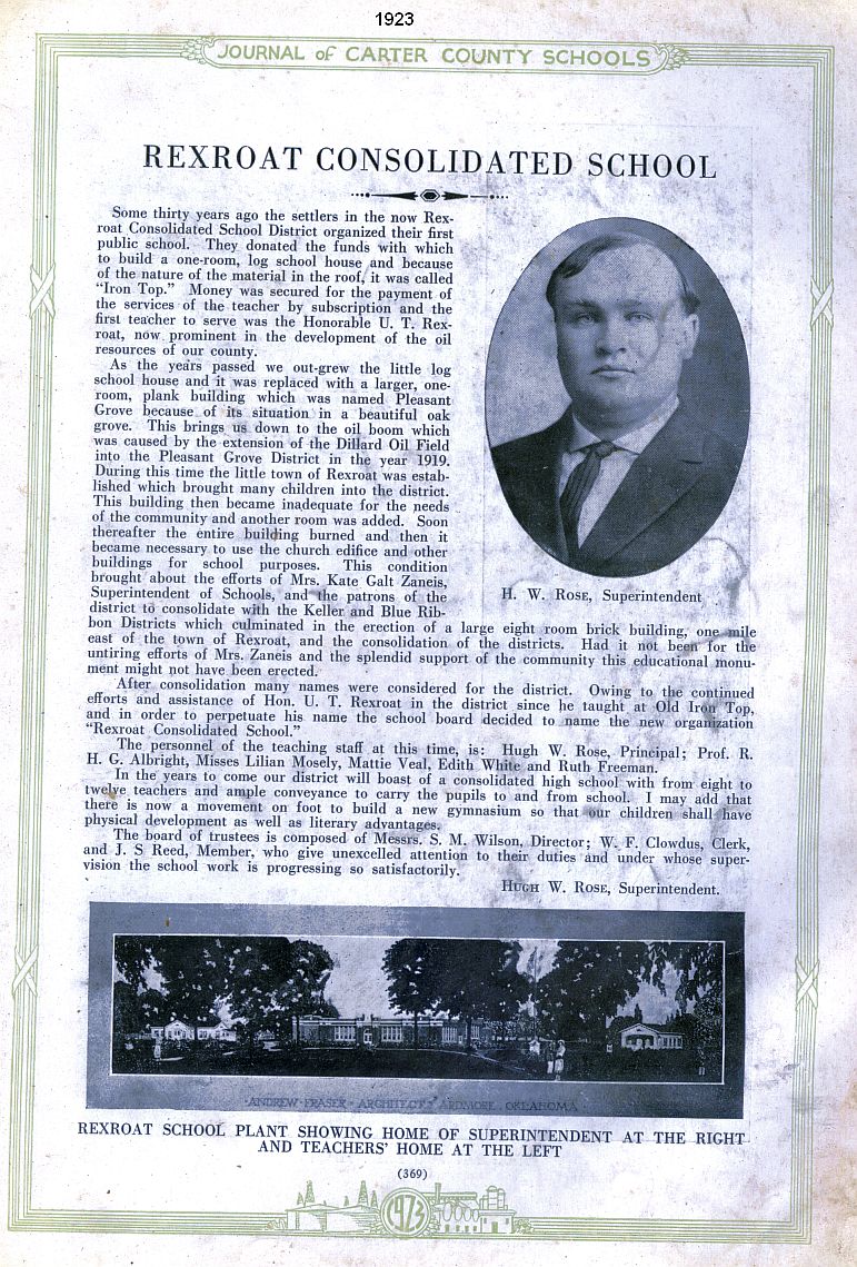
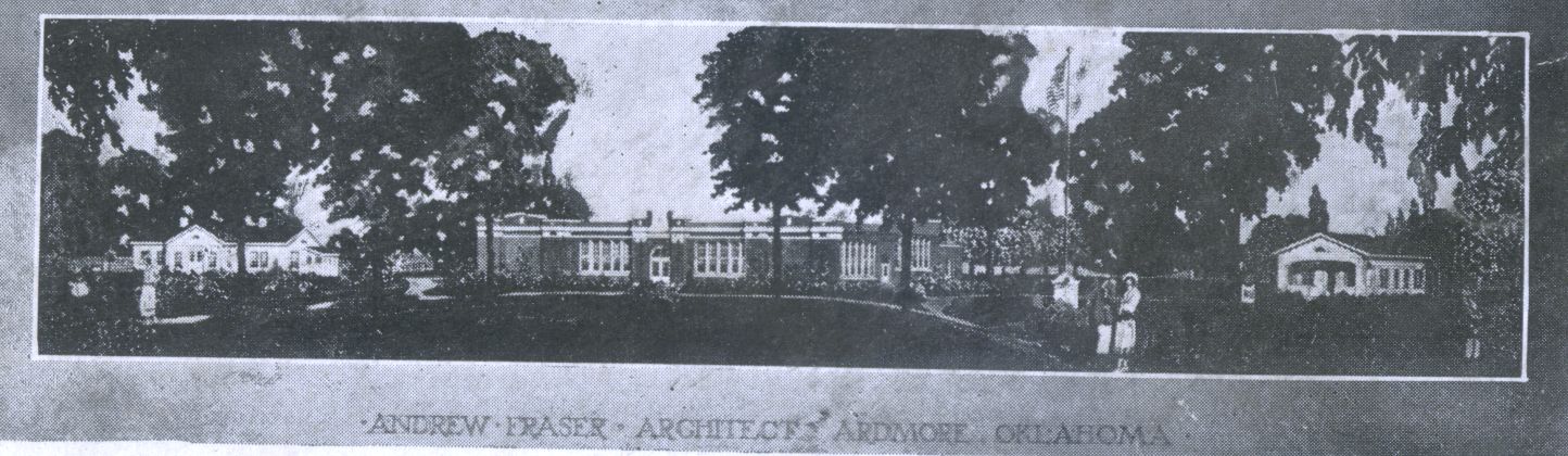
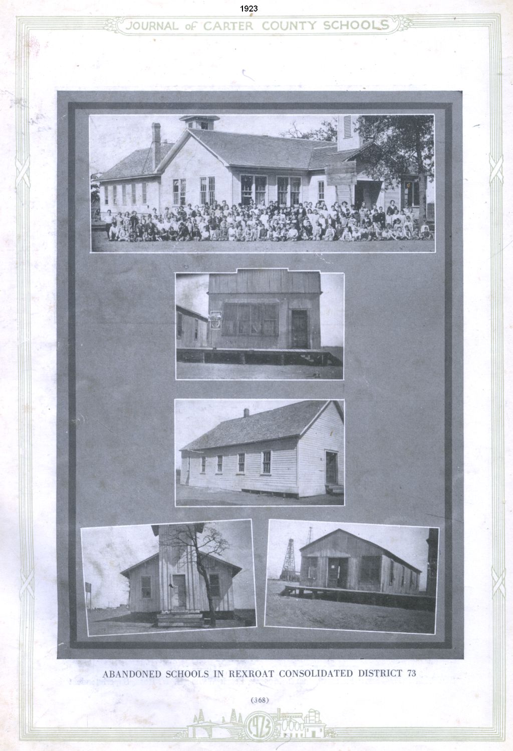
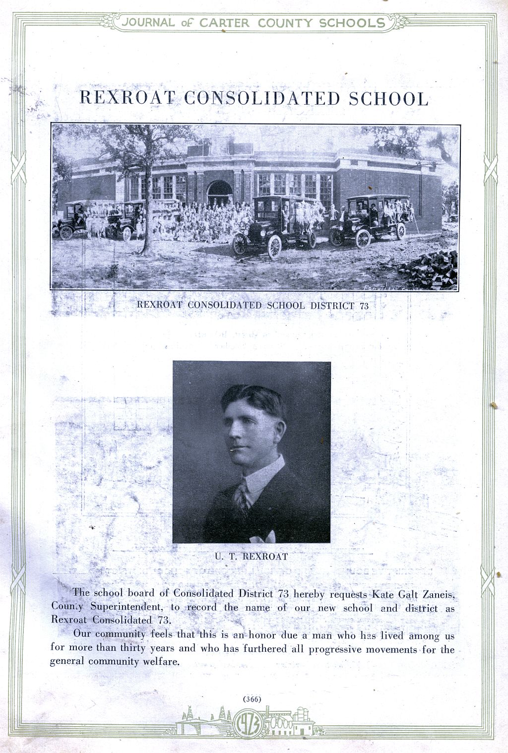
If you travel about 15 miles west of Ardmore on Highway 70, just before reaching the first Wilson turn-off, you come to Dillard Road. Turning north on Dillard road and going 1 mile you come to Dillard, Oklahoma. If you go 2 miles on north you will arrive at what used to be Rexroat, Oklahoma. There is nothing really left of Rexroat, but over 100 years ago it was a thriving community. We know that Rexroat was there about 1890, and really came to life during the oil boom years. The town is named after U.T. Rexroat, one of the first residents and teachers of that community, and later a state legislator. Not to many years ago some of his descendants stopped by to see me and we talked about U.T. Rexroat and how he saw that town grow from a few tents to a full fledged community, with stores and schools. I have scanned the Rexroat pages below from the 1923 Carter county school journal.
https://oklahomahistory.net/ttphotos8a/RexroatSchool1923a.jpg
https://oklahomahistory.net/ttphotos8a/RexroatSchool1923b.jpg
Board members of Rexroat school in 1923 were S.M. Wilson, W.F. Clowdus, and J.S. Reed. Superintendent was Hugh Rose. Faculty were H.G. Albright, Mattie Veal, Ruth Freeman, Lillian Mosely, and Edith White.
https://oklahomahistory.net/ttphotos8a/RexroatSchool1923c.jpg
https://oklahomahistory.net/ttphotos8a/RexroatSchool1923d.jpg
https://oklahomahistory.net/ttphotos8a/RexroatSchool1923e.jpg
https://oklahomahistory.net/ttphotos8a/UTRexroad1923.jpg
From time to time Mark Coe sends in some history of Ardmore’s bygone days, and this week he did just that. I always look forward to Mark’s emails because I never know what new piece of history he will tell. Here is this weeks email:
During the Great Depression, the WPA conducted a series of oral history interviews in Oklahoma. The WPA began as the Works Progress Administration and later was called the Works Projects Administration. The interviews were compiled as the “Indian-Pioneer History Project of Oklahoma”. The following is from the interview with Alfred Owens in Sulphur on April 29, 1937.
“I was born July 28, 1863 in Georgia. I thought this was a better country than Georgia, so I moved to Sulphur in July 1889. I came with an uncle and a cousin in a covered wagon from Texas. It took four days to make the trip. We came by Durant, crossing the Red River at the mouth of Island Bayou. We forded the river at this place. After passing Durant, we came to Caddo. We crossed Blue River at Nail Crossing. We went through Twelve Mile Prairie and crossed the Washita River at Fort Washita. We then went to Mannsville, to Durwood, Provine, and thence to Ardmore.
“Ardmore had only one store at this time, run by Zuckerman. I well remember my first night in Ardmore. They were having a celebration in honor of the Santa Fe Railroad, which had not been built so long before this. [ Note: The first train arrived in Ardmore on July 28, 1887. ] We decided we liked this location. My uncle was looking for grass for his cattle, and this seemed to be the right spot, so we settled near here. I lived here for ten years.
“I began teaching a subscription school here. Each child paid three and a half cents per day to attend. We ran out of water and had to dismiss at the end of three months. The building was a log house about twenty feet long by sixteen feet wide. It had a board floor, and benches made of boards. We had a stove and used wood for fuel. We had a blackboard which I made out of one by twelve boards painted black. I made my own paint out of linseed oil and lamp black.”
July 28, 1887 The first train (Santa Fe Railroad) arrives in Ardmore. The town consists of a few tents, but the train brings lumber and other building supplies. Among the tents were two containing stores. One run by Sam Zuckerman and another by Frank & Bob Frensley. Not a single tree exists within the townsite west of the railroad tracks. Caddo Street becomes the first named street in town. So named because it was originally an old wagon road from the 700 Ranch house north to Caddo Creek.
The Daily Ardmoreite 12-03-1912
The rather unusual sight of an old union veteran and old confederate veteran being buried at the same time and in the same cemetery was witnessed at Rose Hill cemetery yesterday afternoon. Capt. T. B. Johnson, who fought with the federal side and Mike Gray who followed the cause of Lee were both laid to rest at almost the same hour.
The Daily Ardmoreite 12-17-1912
CONSTRUCTION WORK BEGINS
New Christian Church Structure Now Under Construction.
The contractor, B. H. Corlew, has begun the work of actual construction on the $15,000 Christian church building. The forms were all put in Monday and now the work of running the concrete into the foundation is well under way. The building, which is a new departure for this section, in architecture, will be of stone and brick. The stone, about seven carloads in all, will come from the famous Bromide quarries. Architect White who drew the plans for the building and who will act as supervising architect during its erection, stated today to an Ardmoreite reporter that the building would be pushed to an early completion as expeditiously as the weather conditions would permit.
Since Jill and I moved south of Lone Grove I have wanted a water well on our property. I wanted another source of water besides our SOWC meter. Harold Newman lives about 4 miles on southwest of us and is in the water well drilling business, so I contacted him last March about drilling a well. Last Friday I gave Harold the go-ahead to drill. He had already been out and witched for water, we both had witched for water, and both of us determined the same spot, just about 100 feet SE of our house. So early last Friday morning Harold started drilling. At 80 feet he hit the first sand/water zone, but told me that is not the one we need, so he continued on down and hit the 2nd sand and water zone at 120 feet. Harold said this is what he was looking for, so he drilled on down to 185 ft to insure a good well, and a good well we now have too! The water level stays at around 40 to 45 feet below the surface. That gives me about 140 feet standing in the 4 1/2 inch PVC pipe, plenty of water, cold, clear water. Harold said the well was producing about 15 or 16 gallons a minute, so we should never pump it dry and hopefully be a good well for years to come.
I knew there was water there. My great grandmother, Ida Miller, witched for water back in the 30s, and I knew I could too. Last March when I tried my skill at water dowsing on our property, those metal rods would come together and cross with a strong force, every time at the same spot. Harold got the same results when he witched our property. Below are some pictures I took of the last Friday’s drilling.
If you live in the Ardmore area and thinking about a water well, check out Newman Water Well Service a the link below.
http://www.NewmanWaterWells.com
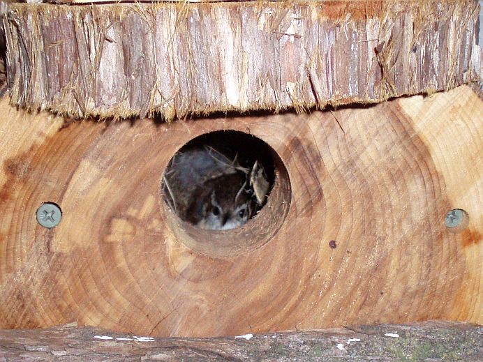
Last week I mentioned about Grovie the Carolina Wren setting on an egg in our birdhouse. Well, since then I’ve looked in the bird house and there are 3 little birdies…. mouths open… waiting for their supper!
Visit the Oklahoma History Boards, start a topic if you want too!
http://oklahomaroots.proboards83.com/
Q. What is Oklahoma’s state rock?
A. Rose Rock – Photo
Q. The first villages seen by the Spanish explorers belonged to what people?
A. (answer in next week’s T&T)
Some mail from this week’s MAILBAG…..“I remember the old Oakley Airport, had my first flight there with Art Oakley in his OX-5 TravelAire. Wiley Post lost his eye when a steel fragment struck him while working as a roustabout in the Healdton oil field. Art taught him to fly shortly after in a Jenny (a JN-4 surplus aircraft from WWI, lots of barnstormer pilots had them, and Art was a pioneer ) Another of Art?s students, Jack Cameron (family owned Cameron Refinery) acquired a plane, and would pick me up on Sunday afternoons and take me fly nag in his Cavalier. A lot of aviation notables came thru Ardmore in those years. When the wooden hangar burned it ended the airport. Several planes were lost, including Lloyd Noble?s cabin TravelAire, a large monoplane, Jack lost his Cavalier, among others. Art?s mechanic was heating the oil for the TravelAire in preparation for a trip, when it caught fire. Art had at that time been hired by Noble as his pilot, and flew for the company until he retired. They acquired the acreage at Springer for a municipal airport and built the large metal hangar with Art doing a lot of the work. John Heasty came to town with a beat up Piper Cub and took over as the operator, and as the war came on, obtained government contracts and operated a flight school, as well as being an aircraft dealer. Bob Goddard and I both obtained out private licenses in 1938 from Heasty, and after the war, Bob took over the operation and operated a flight school under the G.I. Bill, a charter operation and Cessna dealer. Later on an aerial spraying service. Ardmore had a lot of aviation history in the early days, sorry to get wound up, but you triggered old memories!” -Bill Johns
“Wiley Post lived in Ardmore while he took flying lessons. at the place of my early childhood home at 721 B NW. Don’t know how he lost an eye but the patch was a trade mark for him. Springer was the site of my first plane ride.” -Jim Renfro
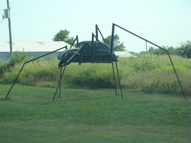
“This creature was constructed at Lexington Oklahoma, at a Body Shop.” -Rus Martin
https://oklahomahistory.net/ttphotos8a/LexingtonOklahomaSpider.jpg
“So that we can get more information on Col Raymond Harvey, the first Chickasaw Indian to receive the Medal of Honor, his education, his classmates while in school in Sulphur, his family, etc, I’m asking anyone who can add information to what we already have will help us understand his life and experiences leading up to the honoring him with the Medal of Honor more challenging and historically valuable.
We are attempting to contact any of his family for help, but so far without avail. His widow’s name is Pamela, his daughters are Cynthia Perieira, Johnece Firestone, Margie Typer, and son Michael Harvey. We will appreciate any information which may lead us to one or more of these survivors. Any of his school classmates while he was attending grade and high school in Sulphur, friends or other relatives, can help us make a more historically correct and informationally factual so that we can the better honor this man of valor. Please contact me at ursm_17848@yahoo.com -C. Roland Earsom
“Moon flowers open in the evening so they can be pollinated by night-flying moths. Like most moth-pollinated flowers, the moon flower is white, which attracts moths. The moon flower is a close relative of the morning glory, which opens in the morning so it can be pollinated by bees and other insects that are active during the day. The moon flower petals die in the morning after they open. On a warm summer night, moon flowers can open in a matter of minutes. You like nature so much that I thought you might like to see our “moon flower” that bloomed this week.” -Sylvia Moore mooreofsylvia48@yahoo.com
https://oklahomahistory.net/ttphotos8a/MoonFlowerSylvia08.jpg
“Hey Butch, I thought some of your readers might be interested in this link even though it is Arizona. Wonder if you could come up with similar things for Oklahoma and specifically Ardmore. Interesting and at times actually very little change over the years.” -Mike Pennington
http://www.azpbs.org/arizonastories/thenandnow.htm
“Hi Butch, I am once again in need of yours or your readers help. Every once in awhile my grandmother will remember something grandpa told her about his childhood.
This is what I know. There was a man by the name of Albert Nolen born in 1878 and died Jan 1935 in Ardmore Oklahoma. He owned some land, on this land he had a Pecan Orchard. I’m thinking Lake Murray was built about 1938 ish. The State of Oklahoma or the Federal Government wanted to purchase this land for the lake. Albert sold his land but asked to be able to keep the last crop that was coming in. I know this land was in the Hoxbar Route area, near the Mary Niblack School. When in Ardmore last summer (I only had about 6 hours to search) I couldn’t find any information at the Court House about this land. However I was able to get information on his mother in laws land which was not suppose to be far from Albert’s. Her name was Malissa Emeline Hollis, she went by Emma. Her second husband was Thomas Sidney Hollis. I did find them in the cemetary as well as Albert and Bertie Nolen (Emma owns the 4 plots) Do you or any of your readers know anything about the Land that Lake Murray is on? Where I could find the information? Or anything about Pecan Orchards in the Ardmore area, I think his land was actually in the Wilson Township area? Since I havent a clue about farming, I thought I would give you and your readers a try at helping me solve this. As well as one other bit of information. Do anyone know of a Holiness Church also in the Wilson area? Grandma says that it might be part of the Pentecostal Religion?? I dont know for sure. Anyways thanks for anything that you or your readers may be able to shed some light on. Feel free to email me back.” kbcook04@yahoo.com -Beth Cook
“Butch: My niece Currewns” started a new website, she is selling Stain Glass Stuff!” http://csstainedglasscreations.com
“Mr. Earsom might want to look at the book, A HISTORY OF PLATT NATIONAL PARK written by Dennis Muncrief. It is softbound and was published in 2007. The book contains history of the area before the white man appeared and then goes on to discuss the history of Sulfur and the park. My only regret is that there are few pictures. Mr. Munchrief has also written a book titled A HISTORY OF FT. ARBUCKLE: IT’S PEOPLE AND TIMES. Last, congratulations on publishing Volume 600 last week. Your effort is applauded.” -Monroe Cameron
“Butch: I have used McAfee, Norton, AVG, Antiviruses. An Antivirus I found on T&T works just as well as any of them! Just need to update daily which takes a very short time. I have been using it on two computers for a number of months with no problems and it is free! I use Windows for a Firewall and have had no problems!” -Hoot http://antivirus.comodo.com/
“While reading about the cost of gas at Love’s, I thought back to when we were kids in the 50’s and 60’s and remembered a little gas station in Davis that sold Gibble Gas, their motto was “If your cars to gobble gas, let it gobble Gibble gas”. We paid anywhere between 9.9 to 12.9 a gallon back then and thought that was lot of money. Compared to today’s prices, we really got over back then.” -Poss
“You will probably get many answers to your question about “how they measured miles” back in the early days. What they did was to make a mark on a wagon wheel and count how many times the mark would ‘come up’ in an already measured mile, and then they would again count how many marks would come up during their travels. It was very accurate and one of my (Warner) ancestors used that method to measure the Pennsylvania Turnpike (before they had automobiles) because the turnpike went through his land and one of the agreements that he signed was that he would have (and maintain) a toll-booth on his land, and collect the toll as folks entered the ‘pike” at that point!” -Roy K.
“Hi Butch: Hope that you and Jill are keeping COOL !! Sure has been hot! I am very well acquainted with Cache Creek as it runs through the Lawton-Ft. Sill area.
As a youngster I swam a good many times in Cache Creek in order to cool off. The creek ran through my Aunt and Uncle’s farm ( Bill and Ona McDonald). The farm was located south of Elgin and north of Lawton; the highway department took a lot of their property when Interstate 44 was built. My cousins and I had a great scare one evening as we were leaving the swimming hole. My eldest cousin was hurrying us to leave the creek – we thought he was just being mean. After we had climbed the bank on the west side he had us look back toward the creek. There, on an overhanging limb, lay a cougar, known to us as a panther. We were a group of scared kids !! There was a lot of wildlife along the creek; panthers, deer and squirrels. The deer would jump the fence enclosures at Ft. Sill and graze on the local farmer’s fields. They were forbidden to shoot the deer; but I know for a fact that venison graced many supper tables in those days.
My Grandfather’s brother, Jim Stamper, was killed while trying to cross Cache Creek where it ran just east of Ft. Sill – it was Thanksgiving Day and they were taking a load of hay to Lawton to sell. There was no bridge there, so they had to cross by going down into the creek bed and up the other side. As they were going down the load shifted, the horses spooked and the wagon was overturned, pinning him beneath it. He was pronounced dead at the scene.
Also, there was a skating rink called Lost Bridge, which was located on Cache Creek, east of Lawton. When I was in High School at St. Mary’s in Lawton it was owned by the Landoll family. I spent many happy hours skating there – it was closed in the winter time as it was not heated; had wooden windows that were raised and hooked to allow a breeze to flow through the rink. We could also swim there.
My Grandmother and Grandfather worked at the “County Farm” northeast from Lawton – Cache Creek ran through that property.
The story is that Cache, Oklahoma, located west of Lawton, was named for the close proximity to Cache Creek. Quanah was selected at first, but the Postal Service denied the request because of Quanah, Texas, which was about 100 miles away. Cache was selected as the second choice. Lawton and Cache have both expanded greatly in the intervening years, and the distance apart is not as great now.
There were times when Cache Creek would flood the nearby fields. Also the low-water crossings were impassable. My Mom said that when she and Dad first farmed just east of Mt. Scott and Lake Lawtonka, the road ran through the center of Ft. Sill, and then on to Apache. In fact, it was known as the Apache Road. (The highway department later built a state highway, that s presently Interstate 44 – it runs through Ft. Sill in the area of the “Old Corral”) There was a low-water crossing on Medicine Creek, and if there was a hard rain, people had to stay in Lawton until the water ran down. Or they could not travel to Lawton for the same reason.
Thanks for letting me tell some of my memories, Butch. Take care and God Bless. -Anna Marie Wilson, Lone Grove amwilson@cableone.net
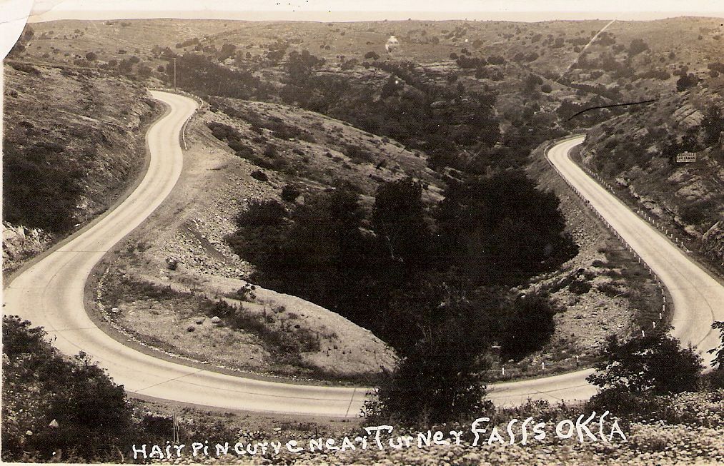
“Hairpin Curve in the Arbuckle Mountains was particularly scary when the road was iced over. But there was really no logical alternative road to go between Oklahoma City and Texas in the days before the interstate.” -Wes Leatherock
“Dear Butch – we have a group of people wondering why there is no “J” street in Ardmore. It jumps from “I” to “K”. Maybe one of your readers knows.”
THE DAYS OF THE OLD WEST by Roy Kendrick
Back in the days of the “Old West”, cattle ranching became almost a craze with some people, and the vast range was extended until it all but covered the Great Plains region of these United States. This was the so-called “cow country” that has become world famous because of numerous books, western movies, and television shows. In the center of this “cow country”, between the huge cattle breeding grounds of Texas, and the feeding grounds of Kansas and other northern states, were the lands known as Oklahoma and Indian Territories. In the northern part of this vast land was the Cherokee Outlet. It was known as this because it had been reserved by the Cherokee Nation as a corridor to the hunting grounds of the buffalo herds in the west. However, the Cherokees seldom used this passage because many of the herds had already been destroyed, and they found better hunting closer to home. So instead, they leased much of this strip of land to the white men for cattle ranching, and in the 1880’s this outlet was to become the greatest cattle country in western Indian Territory. Jesse Chisholm’s famed ‘trail’ brought Texas long-horn and other cattle from those huge breeding grounds of Texas into the feeding grounds up north, and over six million acres of the outlet were leased by the Cherokees to the white man’s Cherokee Strip Livestock Association for a number of years. But as more and more settlers migrated towards the west, the Government was pressured to open the strip to homesteaders. The Santa Fe Railroad extended its branch line south from Arkansas City, Kansas to Purcell in the Chickasaw Nation, Indian Territory in 1887, completing the line to Gainesville, Texas (through what is now known as Noble County, Oklahoma) and a Santa Fe way station was established at Mendota (later known as Wharton) a mile south of present day Perry, Oklahoma.
In 1880, government offices issued orders banning use of the Cherokee Outlet land for grazing and the cattlemen were ordered to leave by October 1st. This strategy was used to compel the Cherokees to sell the lands for settlement, and finally in 1891, they reluctantly agreed to do so. The tribes were paid about $1.40 per acre for the more than 6 million acres, in order to open them for settlement. People from all over the world then headed towards the area, as the government surveyors staked out certain portions for townsites, and land offices were established at Perry, Enid, Woodward, and Alva. Soldiers patrolled the land to keep folks out until the run, and then at noon on Saturday, September 16, 1893, as a pistol shot echoed across the plains, tens of thousands of people raced across the lands in search of homesteads. History has recorded this as the greatest land run ever! The nearest point to enter (to reach the town of Perry) was from the south and just to the east of the town of Orlando in Old Oklahoma. From this starting point, hundreds of horse-drawn wagons and buggies, riders on horseback, and even men on foot, set out to cover the twelve miles to Perry as rapidly as possible. It was estimated that, of the hundred-thousand-plus folks involved in this “biggest land run ever”, over 40 thousand tried to crowd into the town of Perry, and the black dust was so thick and heavy, and water was so scarce, that one new saloon, the “Buckhorn” sold 38,000 bottles of beer the first day at $1.00 a bottle. The next day, they dropped the price to 50 cents a bottle. Within a week after the run, the “government acre” where the land office was, became surrounded by 110 saloons, plus numerous tents, tent “hotels”, cafes. bawdy houses, gambling dens and dance halls (anything to make money from the folks waiting in line to register their claims) and became known as the infamous “Hell’s Half Acre”. It was said that one of the singers in a saloon became very popular by singing a song “After The Strip Is Over” (to the tune “After the Ball is Over”). The day after the run, church services were held in at least one of the saloons.
Famed lawman, William (Bill) Tilghman, who had teamed up with the Masterson brothers to clean up Dodge City, Kansas was hired as the first town marshal of Perry, and Heck Thomas was hired as his deputy. Thomas also had quite a reputation hunting down murderers and train robbers riding the back roads and trails of Indian Territory. Often he would bring in as many as a dozen at a time, tied together with a length of rope. Together, Marshal Tilghman and Deputy Thomas set out to clean up “Hell’s Half Acre” and did so within a year………..but that’s a “whole ‘nother story” that I’ll need to write about some day.
Today the citizens of Perry are proud of their pioneer heritage and celebrate with an exciting week of festivities. It begins with the Noble County Fair, which lasts from September 9th. through the 12th, while the carnival opens downtown on Wednesday the 10th and runs through Saturday the 13th. Friday night will have a home football game with Pawhuska as the opposing team (out at the football stadium, Daniels Field). Also on Friday and Saturday nights (12th and 13th) at 8 P.M. there’ll be a lot of whoopin’ and hollerin’ as the rodeo takes over the Cherokee Strip Arena (out by the football stadium). The big day of course is Saturday, September 13th., when the fun begins in the early morning with the Li’l Settlers Land Run along with a 5-K run and a One Mile Fun Walk. A horse-shoe toss usually begins at 8 A.M. on the north side of the Noble County Courthouse, and live entertainers will perform free at the bandstand west of the courthouse from 9 A.M, till about 5:30 P.M. The Cherokee Arts and Crafts Festival will show and sell handmade treasures (also from 9 A.M. ’til about 5 PM) and staged gun fights will be featured throughout the day. At 10:30 A.M. everyone will scurry to the perimeter of the courthouse square for the excitement of the big parade. This consists of marching bands from high schools and colleges from all over the state, Shriners in midget cars and on motorcycles, numerous floats (they compete for prizes), antique tractors plus a large assortment of Perry manufactured DitchWitch equipment, lots of horses, clowns, and who knows what celebrity might show up to appear in this parade as it winds its way through the business district and around the square. The parade is usually over about noon and then it’s time to eat. Various civic groups and churches have set up concessions stands in a designated area and there are marvelous ethnic foods or barbecue; and even at lunch time, all sorts of events are scheduled to last into the evening hours. However, this years street-dance (normally held until midnight) has been cancelled due to the small number of folks who turned out for last year’s event (I’m told that there were less than a dozen couples who danced!).For additional information about other events, contact the Perry Chamber of Commerce at 580-336-4684. They’re located in the historic Foucart Building at 300 6th Street (the corner of 6th and Cedar). and P.O.Box 426.
The above was submitted by: Roy Kendrick dba Cherokee Strip Antique Mall which is located at 511 Delaware Street (Phone 580-572-8434) Perry, Oklahoma.
“I googled Fred Pyeatt and came up with the following weblinks. Clearly Fred was a lawman in the Ardmore, Carter County area. I’m wondering if those large rocks are not grave markers.
http://www.angelfire.com/ar/pyeatt/ALP1860.html
http://caselaw.lp.findlaw.com/scripts/getcase.pl?court=ok&vol=/appeals/1920/&invol=26985
http://genforum.genealogy.com/ok/messages/21838.html (this one show’s a Mary Pyeatt, 17 yr. old daughter to Mr. & Mrs. A.F. Pyeatt, but do a “Find” and you’ll jump down to a Fred Pyeatt who attended the funeral of Mary)
http://www.ringbrothershistory.com/Columns/column%2061.htm
Bill Gamel was a bit harder to locate any information that wasn’t current. I did find a William Anthony Gamel on a Rootsweb listing that he died in 1904, but not sure where. This was all I could find. Maybe someone more local to Ardmore will have better success.
http://archiver.rootsweb.ancestry.com/th/read/ARRANDOL/2003-03/1047148071
Kathi G.—Fayetteville, AR
“Butch, I found this about a Fred Pyeatt. He appears to have been a deputy sheriff under Buck Garrett. He is buried in Rose Hill Cemetery. I hope this helps the fellow asking about the names on the rocks in the “Ardmore Regional Park”.
http://caselaw.lp.findlaw.com/scripts/getcase.pl?court=ok&vol=/appeals/1920/&invol=26985
“Butch, I am wondering if others have noticed the problem of no butterflies this summer. I live just southwest of Sulphur (near the Chickasaw Park) and last year I took over 100 beautiful pictures of various butterflies in my garden. This year, I have not seen even one. Something must be very wrong here… something has apparently demolished the larva. I have the flowers blooming that they particularly love and yet not one butterfly has arrived. Last year I took many pictures of the tiger and black swallowtails as well as many others. Am wondering if other people in the area are having the same experience.” -Joh in Sulphur
“Carolyn and I drove up to Fort Arbuckle last week and the marker that was right there on the corner of Indian Meridian road about the “Initial Point” is no longer there. There is a marker there about Fort Arbuckle though. The property where the fort was is sure pretty, wish I had the cash to buy it. The location is West of Davis on Highway. 7. After crossing I-35 it’s about 3 miles on West to Indian Meridian Road. Turn right (north) and then at the second cattle guard on left side of road take it and you’re there.”
“Hello Butch, Cache River would be Cache Creek. It runs from Red River through Lawton and Fort Sill and heads into the Witchia Mountains SW side of Mt Scott.” -Earl D. House in Sand Springs, OK
“Hey Butch, just lookin’ @ this weeks TNT, and I do believe that Harley Ford belongs to my husbands friend and his wife, Jesse and Trish James of Ardmore. Also Harley has put out a Ford pickup every year since 2003. The 2008 is the 105th anniversary addition, you should check out the new “Super Duty”, what a beauty!! But, who can afford the fuel?? Anyhow, just thought I’d let the readers know that there is more than 1 year model. Sure are pretty to look at, but do come with a VERY PRETTY price tag!! LOL!!!” -Jammey Howard
“Dear Butch and Jill, I just thought I would drop you a line and make a couple of points in return to a couple of your received emails last week. First of all, the origin of the “hamburger” was in 1883 in Hamburg, Germany. Gustav Flanderson is the originator of the meat on a bun. He was the first to combine onion, lettuce, and mustard on a grilled ground cow. Secondly, I read where someone wanted to know the name of the town where the movie on Bass Reeves was filmed. The town is over at Reagan, Oklahoma. It is a movie set built by a guy named Johnny Shackleford. Johnny is one of the nicest fellows you will ever meet and his cousin cooks one of the best hamburgers you will ever put in your mouth at that movie set. The movie was named, The Black Marshall, the movie set is named, Sipokni West.”
The Wilson News by Mindy Taylor
11-03-1916
W. M. Wormington has decided that Wilson is a splendid place for a plumbing business and put in a complete line of plumbing supplies last week next door to News office. He will also handle sheet metal. Has been at the game for 25 years and suffice it to say assures satisfaction to all.
Sam Allard and W. T. McPherson will open up a line of 1917 styles in wall paper in the News building immediately. These boys have been in the business in some of the leading cities of Texas and Oklahoma and know it from the first principles up to the latest ideas in classy interior decorating.
L. H. Webb, contractor and carpenter, has located here. He is also prepared to do small jobs of wood work, painting, etc…
J. A. Conner has moved into a building near the News office and is now prepared to write you up a life insurance policy or real estate lease.
A Brand New Store: B. P. David & Son – General Merchandise – Look for the new brick store on Main Street, near W. B. Gill’s office.
City Barber Shop: E. J. Woods, Prop. – Located on North side near Mobley Corner. We appreciate your barber trade. Give us a trial.
Hudson Houston – Don’t forget we have plenty of Colorado and McAlester coal – Phone 32
Clowdus & Bridge – watchmakers, jewelers, expert watch repairing – All Work Guaranteed – Location: Crescent Drug Store
Please remember that 82 is the phone number of the assistant editor and that any and all news items you will report in to her will be gladly received and promptly handled. Phone 82. – Wilson Museum hours: Tues., Thurs., Fri., Sat., 10:00 a.m. – 4:00 p.m.
“Nature is the greatest teacher and I learn from her best when others are asleep. In the still dark hours before sunrise God tells me of the plans I am to fulfill.” –George Washington Carver
See everyone next week!
Butch and Jill Bridges
Ardmore Oklahoma
PO Box 2
Lone Grove, Oklahoma 73443https://oklahomahistory.net
Save on long distance calls, just a couple cents a minute!
http://www.CheapLongDistance.org
Oklahoma Bells: https://oklahomahistory.net/bellpage.html
American Flyers Memorial Fund – Administration Webpage
https://oklahomahistory.net/crash66.html
Official American Flyers Memorial Website
http://www.brightok.net/~wwwafm
Ardmore Army Air Field/Ardmore Air Force Base Website
http://www.brightok.net/~gsimmons
Mirror Site of the Ardmore Army Air Field/Ardmore Air Force Website
https://oklahomahistory.net/airbase/
Carter county schools, past and present
http://community.webshots.com/user/oklahomahistory
Carter County Government Website
http://www.brightok.net/cartercounty/
All previous issues of This & That can be found on my Website.
Feel free to forward this free newsletter. Mailouts: over 1,600.
To be removed from my T&T mailings, just send me an email.
I do not sell, trade or give my mailing list to anyone for any reason.