This and That Newsletter
www.OklahomaHistory.net
Vol 23 Issue 1,168 Circulation 5,000 June 13, 2019
Ardmore, Oklahoma
My permanent email address: butchbridges@oklahomahistory.net
580-490-6823
Healdton Herald
The year 1916 marks the beginning of the Healdton Herald, a weekly newspaper. In 1924, it was purchased by Homer Hedges, a young man of 23 years, but you had been printing since age 13. The news editor was Burt Huddleston, and his pressman was Ewing Hedges. In 1959, W. D. Chaffin and his two sons, Kenneth and Jim, purchased the paper. It has now grown to a circulation of 2,000. The Herald is a family project, as Mrs. W.D. "Maxye" Chaffin is the bookkeeper, and Jim and Kenneth are the printers. Their wives Cleo and Linda, punch tape and proofread the copy. W. D. spent 25 years as advertising and business manager of The Daily Ardmoreite, before assuming the leadership of the Healdton Herald. The business has a large commercial printing operation as well, as they own and print the Wilson Post-Democrat.
-Indian Territory and Carter County Pioneers book 1982Note: Cindy Dickerson is the present managing Editor and Co-Publisher of the Healdton Herald.
Q. The outdoor playground at this children's museum in Oklahoma is one of largest of its kind in the world. Where in Oklahoma is this playground?
A. Adventure Quest Playground is located at Leonardo's Children's Museum in Enid, Oklahoma
https://www.onlyinyourstate.com/oklahoma/leonardos-childrens-museum-ok/?utm_medium=email&utm_source=oklahoma&utm_campaign=newsletterQ. Where in Oklahoma are more than 2,000 historic buildings located?
A. Answer in next week's newsletterApril 1935
The Mannsville High School collapsed and sent debris crashing into the crowded classrooms. Miss Roberta Collins suffered cuts on the hands and arms and Miss Dorothy Chaffin was struck on the head by flying lumber. A tremendous rainfall accompanied the storm. The rainfall measured a peak of 3.45 inches and brought relief from dust storms which had blanketed the section. During the height of the dust storms 36 truckloads of furniture for counted moving east easterly as choking clouds of dust tore down the telegraph lines.April 1935
John Smith, Thackerville Constable, was back in the Love County Jail facing murder charges for the slaying last summer of sheriff Sam Randolph. Smith was captured in Texarkana, Texas and return to Love County by Sheriff Orin Wester. He had jumped bond and disappeared just as he was to go to trial. "I'm glad to be caught," Smith told Wester. "I'm tired of dodging officers at every corner."Below are some pavers and gravestones I made this week.
http://www.oklahomahistory.net/bricks/LPMinitials.jpg
http://www.oklahomahistory.net/bricks/BuddyDogGranite.jpg
http://www.oklahomahistory.net/bricks/OllieCatSetInGround.jpg
Below is from This and That newsletter archives of June 13, 2007
Last week when we mentioned the "county home" that used to be at Myall and the railroad track crossing mainly during the Great Depression Years during the 30s, and continuing into the 40s. The "home" was a place were those without a job, a place to live, food, or care could stay, all provided by the county. Several of you wrote in with more information.
"Dear Butch, It was with great interest that I read the article that you wrote following your conversation with Iris Larson regarding the old "County Home". My parents, Dessie and Virgil Harris were good friends of the Arnolds who ran the place. I recall in the late '30s going out to the place and seeing the lush vegetable garden that they cultivated for their food. At my age at that time, probably 8 or 9, I didn't really comprehend that other folks really had no home, job, or source of daily food. I recall that there were a few elderly men (I don't remember any women) residing there at that time. I will be very interested in reading the related document from Ms. Larson that you mentioned once you have it scanned. Thanks for keeping us long gone from Ardmore old timers up on events that we recall from those days past." -Virgil Harris (Jr.)
"Our family lived about a half block from the county home Iris Larson spoke about in your last issue. As a boy during the 1940's, I remember the residents welcomed my occasional visits into what must have been a fairly dreary existence.. Their living quarters were not much more than clapboard shanties but my impression was they were glad to have a roof over their heads. Meals were prepared by Mrs. Arnold at the main house. In addition to a cow, pigs were raised and then slaughtered in the fall. I have learned since that "county homes" for the indigent were commonplace throughout the country and were a result of the depression of the 1930's. The cellar for this county home was still there at Myall and C Streets the last time I visited Ardmore. It was used to store all the canned goods from what seemed to me an immense garden raised by the residents. I think this county home closed sometime in the late 1940's." -Jim Lewis JLEWIS8585@aol.com
"Butch: Before her death, Patty Norton (1919-2001) told me that when she was a child, she and her mother. "Miss Hallie" Saxon, frequently walked down Myall street from their home in the southeast part of Ardmore, each carrying a syrup bucket of homemade soup. Their first stop was at the "poor farm" where they hand-fed the sick and afflicted before going on to the Confederate Home to do the same for the old veterans who lived there. Patty was born in 1919 so this would have occurred five or six years later, I suppose." -Sally Gray
-------------------------------------------------------------------------
"Hi Butch: I read with interest the article about the "County Home". My grandparents, Jack and Emma (Stroud) Stamper, ran the "County Farm" in Comanche County in the 1940s. It was located east of Ft. Sill and north of Lawton. There was a nice big house for my grandparents, and a house across the driveway where 8 old gentlemen lived. Grandma prepared all their meals, and they were served in the big dining room in the house where my grandparents lived. Grandpa took care of all the cattle and farming - some of the old gents helped gather the eggs and helped with the milking - if they were able. I remember doing the "churning" on the big screened back porch there. The churn was the one with a long pole that you pulled and pushed down. Sure was glad when Grandma got a "Daisy Churn". I was only 6 years old at the time, but would love to know if anybody knows anything about the farm. I don't think there were any women there; at least I don't recall seeing any. Some of the men had medical problems and some had mental problems. When their health failed, my grandparents moved to a home in Lawton - about 1942. Also, does anybody in the Lawton area remember "Munn's Cabins" - a motor court as they were called then. My aunt and uncle lived there briefly when he was stationed at Ft. Sill prior to WW II. Munn's Cabins was where you turned east to go to the County 'Farm - about where Rogers Lane is now. When you turned off the dirt road, there was a long lane to the house. Would appreciate any information. Thanks a lot." -Anna Marie Wilson in Lone Grove, OK
-------------------------------------------------------------------------
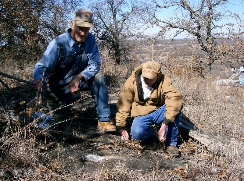
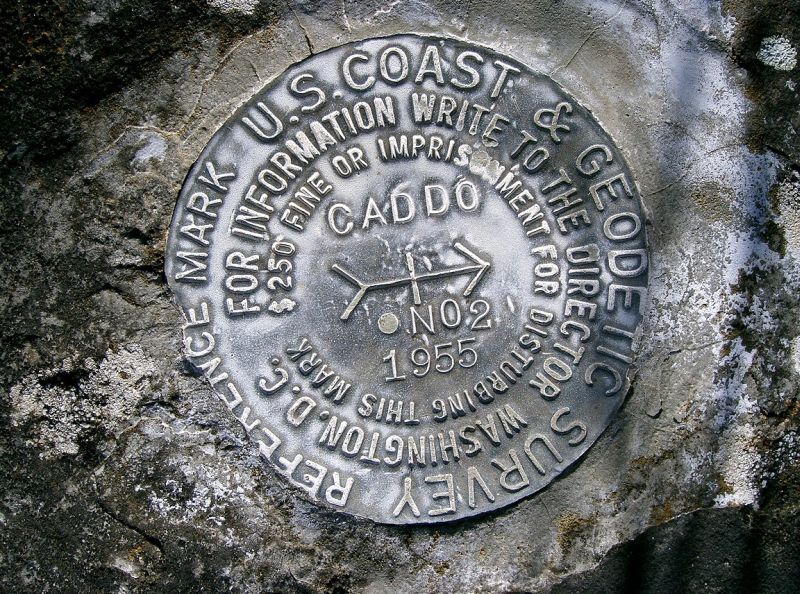
"Butch, I finally found the photos you requested. Shown in the photos are Tom Mumford and his Grandson Payton Mumford. They are the ones that took me to the location of the marker. It's located on top of a hill that is on or very close to the Carter-Stephens County line about three miles west of Fox, Oklahoma. Tom lives near the gas plant just immediately west of Convict Hill. The marker would be approximately 2 to 2.5 miles NW of Convict Hill. It's accessible only by oil lease roads. One photo shows how high up the marker is on the hill and a view toward the north from that spot. The marker is embedded in that large rock they are looking at." -Dwane Stevens
http://www.oklahomahistory.net/ttphotos7a/GeodeticMarkerHarleyHill04a.jpgU.S. Coast and Geodetic Survey Reference Marker
http://www.oklahomahistory.net/ttphotos7a/GeodeticMarkerHarleyHill04b.jpg
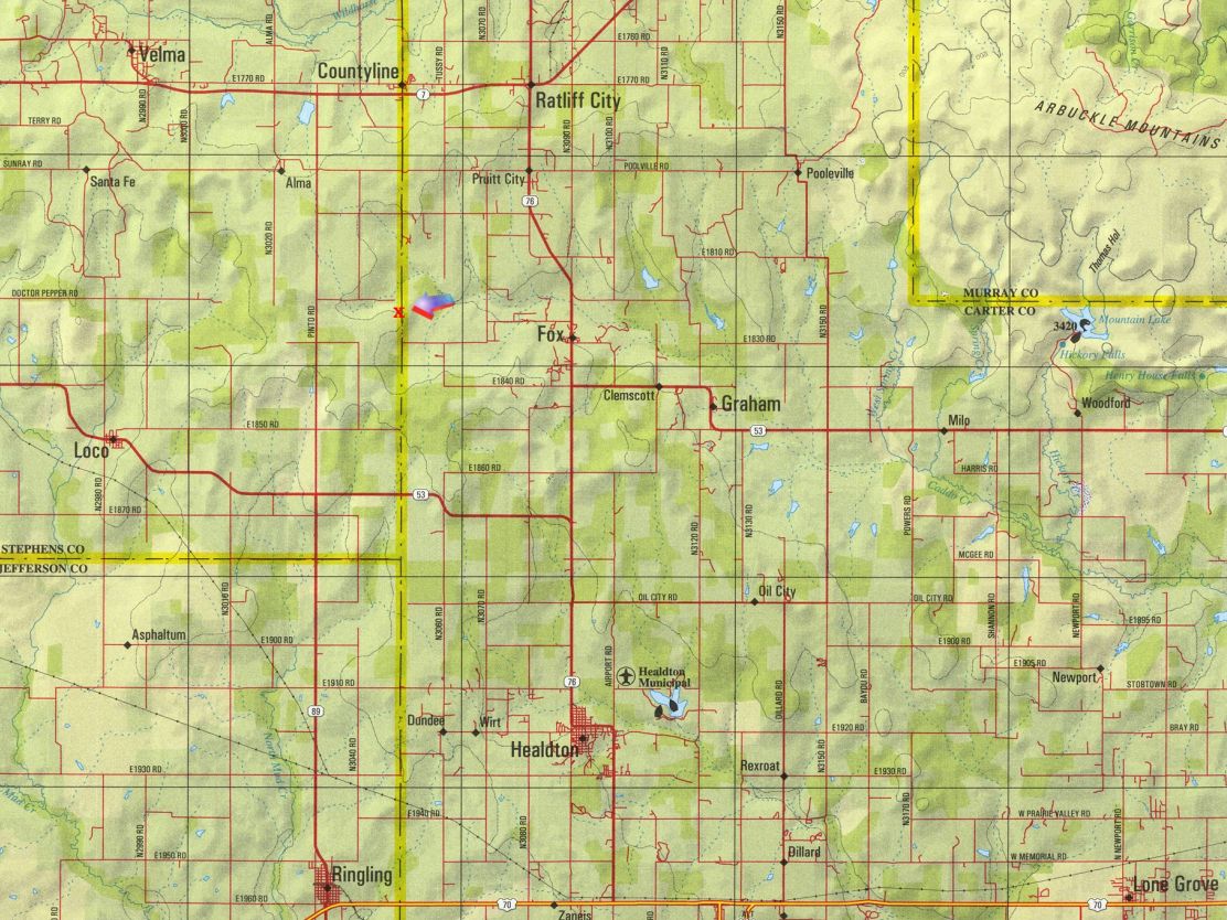
Below is a map with approximate location of the marker and approximate coordinates.Longitude : -97.56983
Latitude : 34.37264
http://www.oklahomahistory.net/ttphotos7a/GeodeticMarkerMap.jpg
-------------------------------------------------------------------------
-------------------------------------------------------------------------Some mail from this week's MAILBAG.....
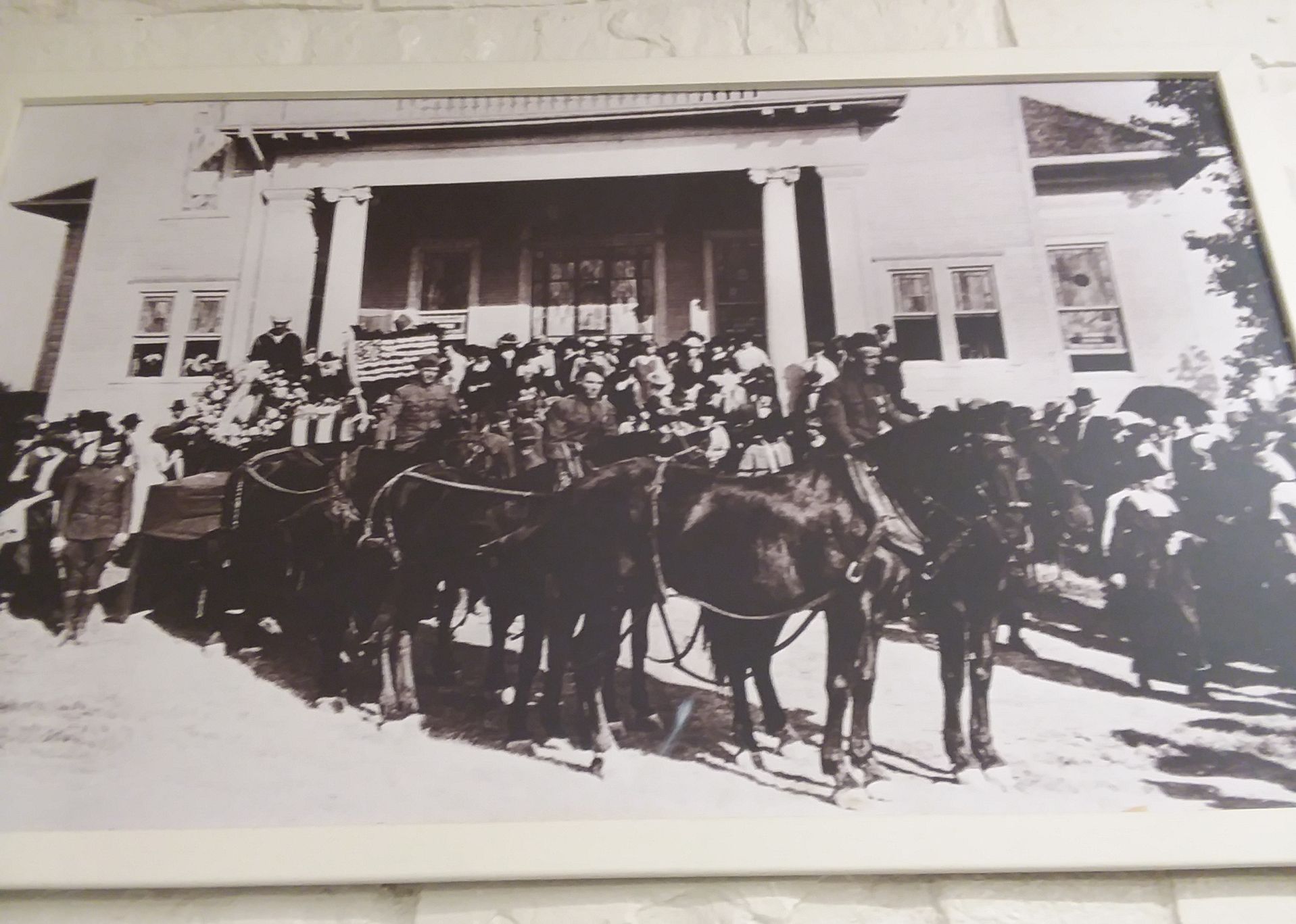
Butch, that photo in the military museum, the building looks like what I remember the old Seventh-day Adventist church looked like. It was next to the funeral home, and across the street from where an old hospital was, and then the post office was built. Am I right on that?
http://oklahomahistory.net/ttphotos19a/ArdmoreMuseumPhotoUnknown.jpg
-----------------------------------------------
-----------------------------------------------"Brother, Can You Spare a Dime," (1931)
The Great Depression Years
They used to tell me I was building a dream, and so I followed the mob,
When there was earth to plow, or guns to bear, I was always there right on the job.
They used to tell me I was building a dream, with peace and glory ahead,
Why should I be standing in line, just waiting for bread?
Once I built a railroad, I made it run, made it race against time.
Once I built a railroad; now it's done. Brother, can you spare a dime?
Once I built a tower, up to the sun, brick, and rivet, and lime;
Once I built a tower, now it's done. Brother, can you spare a dime?
Once in khaki suits, gee we looked swell,
Full of that Yankee Doodly Dum,
Half a million boots went slogging through Hell,
And I was the kid with the drum!
Say, don't you remember, they called me Al; it was Al all the time.
Why don't you remember, I'm your pal? Buddy, can you spare a dime?https://www.youtube.com/watch?v=4F4yT0KAMyo
See everyone next week!
Butch and Jill Bridges
"Friends Make Life Worth Living"PO Box 2
Lone Grove, Oklahoma 73443http://www.OklahomaHistory.netVicious Dog Attacks in Oklahoma
http://www.oklahomahistory.net/viciousdogs.html
Oklahoma Bells: http://www.OklahomaHistory.net/bellpage.html
Bill Hamm's Cemetery Database
http://www.usgwarchives.net/ok/carter/cartercm.htm
American Flyers Memorial Fund - Administration Webpage
http://www.OklahomaHistory.net/crash66.html
Official American Flyers Memorial Website
http://www.brightok.net/~wwwafm
Ardmore Army Air Field/Ardmore Air Force Base Website
http://www.brightok.net/~gsimmons
Mirror Site of the Ardmore Army Air Field/Ardmore Air Force Website
http://www.OklahomaHistory.net/airbase/
Carter County Government Website
http://cartercountyok.usT&T Sign Up Form
* indicates required
All previous issues of This & That can be found on my Website's archives.
Feel free to forward this free newsletter. Mailouts: over 1,400.
To be removed from my T&T mailings, just send me an email.
I do not sell, trade or give my mailing list to anyone for any reason.