This and That Newsletter
www.OklahomaHistory.net
Vol 24 Issue 1,202 Circulation 5,000 February 6, 2020
Ardmore, Oklahoma
My permanent email address: butchbridges@oklahomahistory.net
580-490-6823
A Glimpse into the Past
Fire Caused Disaster
Ardmore continued to grow during the early 1890s, and farmers in the area produced bumper crops of cotton, corn, oats, cattle, hogs, fruits and vegetables from the fertile soil. Ardmore was the principal marketing center f or all of what was to become Southern Oklahoma. On Oct. 28, 1893, The Daily Ardmoreite newspaper was established, destined to serve the city and area into the long future.Since Ardmore had no city government, there was no police department, no fire department nor other city services. The only water supply was from wells and cisterns, inadequate for fighting major fires, and this led to Ardmore's first great disaster of its early years. On April 19, 1895, in the early morning hours, fire broke out in a livery stable on North Caddo Street and within a few hours swept through the main part of town, destroying 82 business buildings and residences. The young city was practically wiped out, but the citizens went to work to build back and within a few months Ardmore was in operation again.
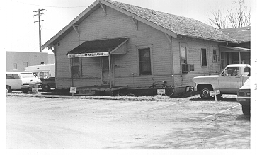
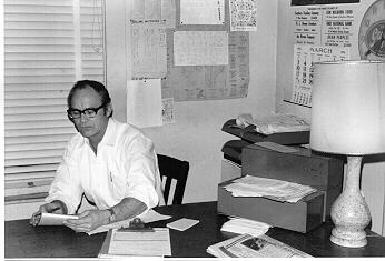
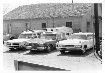
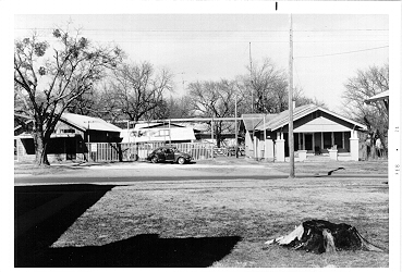
-Indian Territory and Carter County Pioneers book 1982With all this snow and ice yesterday my mind flashes back to my ambulance days at Southern Oklahoma Ambulance Service in Ardmore. In the early 1970s we had a 1967 Chevrolet station wagon converted into an ambulance. Our office was in the south parking lot behind the Ardmore Adventist Hospital in an old house (photo below). We had no garage so in the dead of winter our 3 ambulances were parked outside. When we thought it would snow/ice we'd cover the windshield over with a bed sheet. When the phone call came in in the wee morning hours we'd jump up and run out the front door to the ambulance, open the doors and throw the frozen sheet to the ground and take off. Sometimes, depending on how far we went, the cot and inside would be warmed up, other times the cot was still cold. I know when we moved the patient over to the cot from her warm bed, she probably thought was is this? But that's the way it was back in those days. We didn't have chains, slowed us down to much, so roads were really slippery sometimes. I remember leaving for OKC one evening in the dead of winter in the "hearse type" high top Cadillac ambulance we had with ice all over southern Oklahoma. I could only drive about 15 MPH on I-35 if that. I got as far as Springer (9 miles north of Ardmore) and turned around and came back to the hospital. My boss, Bill Lewis, got mad a me for not continuing, but I thought this is too dangerous on this ice. Medics today have no idea what 4 of us went through 24/7 back in those days to provide ambulance service. I loved my ambulance days and proud to do my part as best we could with what we had.
http://www.oklahomahistory.net/photos2/3amb.jpg
1938 B&L Jewelers, Ritz Theater Building, Laurence E. Beattie and M. Victor Larsen
1938 Thompson's Cafe 200 West Main
Oklahoma had the largest population of Socialists of any state in the period before WWI.
Q. Up until 1942, Oklahoma would surgically sterilize criminals for what reason?
A. 1942 and before, Oklahoma surgically sterilize criminals under the belief that bad behavior was hereditary.Q. In 1964 Oklahoma City was subjected to what 8 times a day for 6 months to test the population in an experiment?
A. Answer in next week's newsletterBelow is from This and That newsletter archives of February 14, 2008
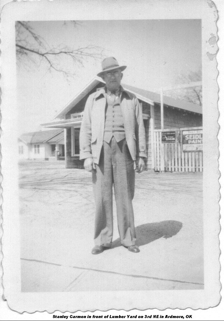
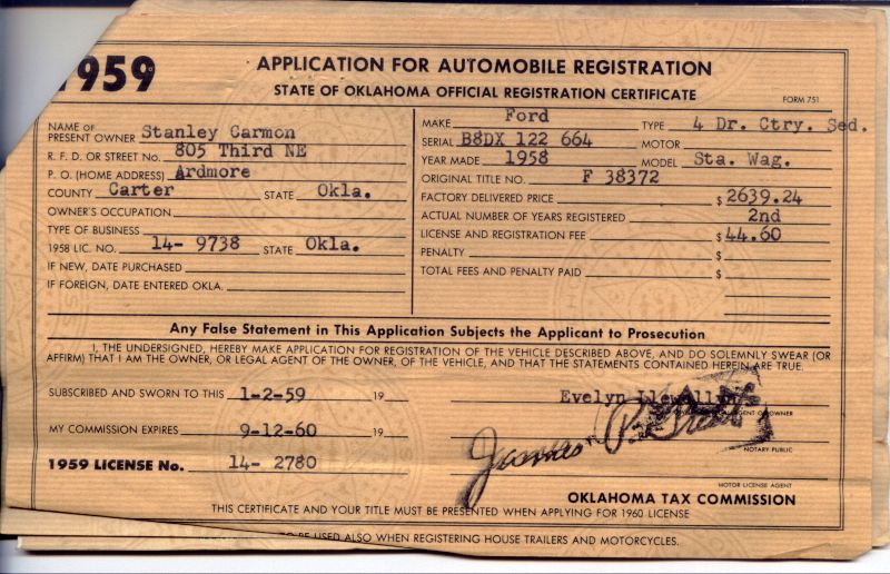
Back in the 1950s my grandfather Stanley Carmon owned a 1958 Ford station wagon something like the one in this picture as best I remember except ours was yellow.
http://www.stationwagon.com/gallery/1958_Ford_Country_Sedan.html
Below is a scan of the Oklahoma car Title to the station wagon.
http://www.oklahomahistory.net/ttphotos7a/1958StationWagonTitle.jpgWe made several trips to Dallas (actually Mesquite, TX) to pick up paint and wallpaper at the Dal-Worth Paint Mfg Company to sell in his lumber company on 3rd NE. I remember one school day morning hiding under a tarp on the floor behind the drivers seat and I didn't move until we got way south of Ardmore. When your hiding a minute seems like 30, so I thought we were further down Highway 77 (no I-35) then we really were. When I did move and say something, my grandfather was pretty mad, but he let me continue on to Dallas with him.
---------------------------------------------------------------------
I sure enjoyed riding in that station wagon, and the one thing I remember is it had an Overdrive. Not many vehicles back then had that feature. It was a real gas saver on the open highway. And then on a steep uphill, you didn't have much power. But the station wagon back in my teenage years was a completely different station wagon from the modern day back 100 to 200 years ago. The station wagon was just that, a wagon used to transport people from the hotel to the train station and back.
---------------------------------------------------------------------
"Hi Butch, Re: the new Catholic Church in Marietta, the general contractor is our own Bill Fields of Craftco Builders here in Ardmore. You might know his father-in-law, former county treasurer Mike McComber."
http://www.OklahomaHistory.net/ttphotos7a/MariettaMission7a.jpghttp://www.OklahomaHistory.net/ttphotos7a/MariettaMission7b.jpg
http://www.OklahomaHistory.net/ttphotos7a/MariettaMissionBell.jpg
---------------------------------------------------------------------
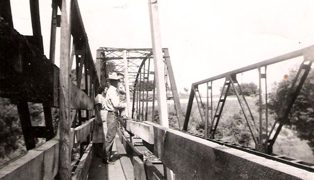
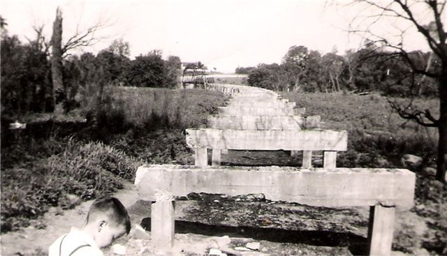
"Butch, here is a picture of the river bridge on the east side of the Airpark by Annie Conway's place after it had burned, circa 1950. The man in the cowboy hat is I believe my grandfather Frank Rountree, they were standing on a walking trail made to get across the river. If you zoom in there is an old Ford pickup on the hill. The bridge was converted to a Bailey bridge later by the Air Force." -Doug Williams
http://www.OklahomaHistory.net/ttphotos7a/AirparkBridge7a.jpghttp://www.OklahomaHistory.net/ttphotos7a/AirparkBridge7b.jpg
---------------------------------------------------------------------
"I live on the property where the Pruitt school house was located. It is about 2 miles East of Ardmore on Gene Autry road, one half mile North of hi-way 199. The corner of Gene Autry and Quail roads. It is on the South side of the Pruitt cemetery. I believe cemeteries and school houses were located next to each other back in the old days. All that's left are two brick columns by the road, a big cellar, and the foundation of the outhouse. I've had most of the other foundations removed. I've been looking for a photo of it for years. Can anyone help? My parents lived here for almost 40 years before I moved here in 2000. My understanding is it burned down around 1929 and was never rebuilt. Apparently it was a brick building and when it burned all the brick were spread out and covered with dirt because any where you dig there are brick. And there are seven acres of it. My friends have had a field day with metal detectors out here. I have a 1903 penny that looks new. Probably some child dropped it while playing. That had to be lots of money back then. Also found some Oklahoma "mills" (1/10 or 1/2 pennys)." -Larry Caillr@aol.com
---------------------------------------------------------------------
"Dear Butch and Jill Bridges: My name is Jerome Benson 78 years old, Chula Vista, CA. Your Oklahoma History awoke me from what I thought was a touch of Alzheimer's. Suddenly I can recall almost before I was born. I was raised a mile north of Ravia on a small dried up farm on a dirt road. When I was not yet in my teens, the Kuykendall family lived just north of us before moving to downtown Ravia. The Clark Capertons lived a 1/4 mile south. Nina Ruth Kuykendall, and her brother a couple of years older than I, were walking down the dirt road and a snake bit her. They both screamed that she had just got snake bit. Dad, Homer Benson, jumped into his wagon and team which was already hooked up and raced to them as fast as the team could run. He ran them all the way to Ravia for treatment and saved her life. As for me, as a teenager there, I was ranked as a topnotch cotton picker at a penny per pound, black eyed pea picker on the thirds, dishwasher at Park's restaurant in Tishomingo for $5 per week and all the gizzards I could eat. What deals. Clark Caperton was a good family friend. We kids called him Mr. Yeah Yeah because as he listened to someone he would say yeah yeah. I remember he was a compliment to Ravia as few others were during those wild years. My Benson grandfolks were old timers there even before the turn of the century. My mom's mother was full blood Chickasaw from Pontotoc. Gene Autry went to school there from the first year to the tenth grade. His dad was in prison for cattle rustling when his mother died of malnutrition. Gene was singing on the radio at the time and called Earnest (Red) Field's son to please get his (Gene's) two sisters something to wear to the funeral. Red's son J. E. paid $16 for the clothes. Previously to that when Gene was going to school, Red bought Gene a second hand guitar for a dollar. That was the beginning of Gene's success story. My daughter is a doctor of Public Relations. She recently returned from London where she taught at a branch of Oxford University. While there, she went to a Protestant and Catholic meeting in Belfast, Ireland. The Irish as usual almost got into a fight while arguing. On the outside in the hall was a chalk board. On the way out my daughter wrote, "I am Chickasaw Indian from Oklahoma. Instead of arguing and fighting, we Chickasaws sit on a big flat rock with a peace pipe and blow smoke to the four winds and leave as the best of friends. Thanks Butch and Jill for reviving my young years." ejb@nethere.com
---------------------------------------------------------------------
Find Open Source alternatives to commercial software. http://www.osalt.com/
---------------------------------------------------------------------
"My name is John Gow. jag25_136@hotmail.com I lived in Ardmore and went to junior high and high school there in the late 60s and early 70s, though I haven't lived in Ardmore for many years. I learned of your publication from a man in Australia, Ron McFarlane, while talking with him about railroads in Ardmore in the 1960s. He is a big fan of the Santa Fe Railroad through the Pauls Valley and Ardmore area and has been creating a model railroad in its image. In high school I was likewise a big fan of the railroads in Ardmore (or anywhere, for that matter) and had taken a lot of photos of trains in the area at that time. I told him as much as I could remember of what the railroad operations were like at the time, and also sent him some of my photos. He told me of your publication and said you might be interested in seeing the photos as well, so here are a few. If you're interested I have more. Some info on the photos:
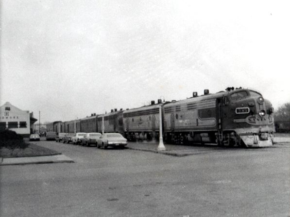
1) This is Santa Fe's southbound Texas Chief, arriving at the Ardmore station in 1971. The Texas Chief was a passenger train that ran daily between Chicago and Houston. It had a baggage car, chair cars, sleeping cars, a full lounge car (what the Santa Fe called a "Big Dome Lounge", as it had a glass bubble top and you sat up inside the dome, almost like you were sitting on top of the train), and a full-service dining car serving breakfast, lunch, and dinner. The southbound train was scheduled to arrive in Ardmore about 11:30am. This station still stands of course, and now serves Amtrak's Heartland Flyer. To the left of the train in the parking lot you can see the beginning of a grass median. This was actually a rose garden, maintained for many years by the Ardmore Garden Club, as an enhancement for travelers arriving and departing Ardmore.
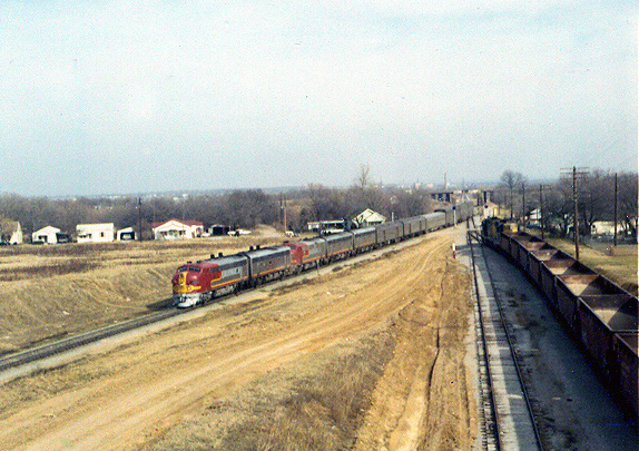
http://www.OklahomaHistory.net/ttphotos7a/ATSF15Ardmore1971_1.jpg2) Here is another view of the southbound Texas Chief coming into Ardmore in 1971. This photo was taken looking north from the MLK Viaduct, though at that time it was called the 5th Street Viaduct. There is a northbound freight train on the right waiting for the passenger train to pass before it moves out onto the mainline to continue to Oklahoma City and beyond.
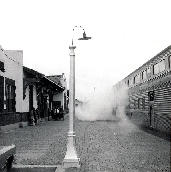
http://www.OklahomaHistory.net/ttphotos7a/SantaFeTrain1971_2.jpg3) Here is the northbound Texas Chief in the Ardmore station, stopping on its way to Oklahoma City, Wichita, Kansas City, and Chicago. The passenger cars are Santa Fe's "Hi-Level Chair Cars", a 2 story type of car with an upstairs and a downstairs. Amazingly these durable, comfortable cars are still in use on Amtraks' Heartland Flyer which continues to serve Ardmore today. The northbound train was scheduled to arrive in Ardmore about 3:15pm.
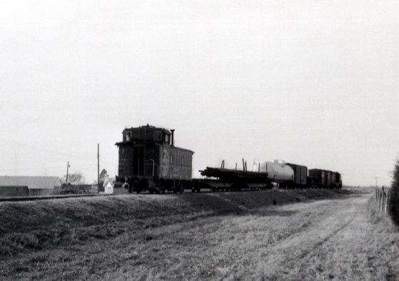
http://www.OklahomaHistory.net/ttphotos7a/ATSF16Ardmore_3.jpg4) This is Santa Fe's branchline freight train that ran from Ardmore to Healdton and Ringling. The train is shown leaving Ardmore in March 1971 westbound to Healdton and has just crossed Sunset road on the southwest side of Ardmore. At this time the little train ran 2 times a week, on Tuesday and Saturday. The new Uniroyal Tire Plant (at this time it was brand new) is about a mile and a half ahead and is still served by this rail line, though the line beyond the tire plant to Healdton and Ringling was abandoned long ago.
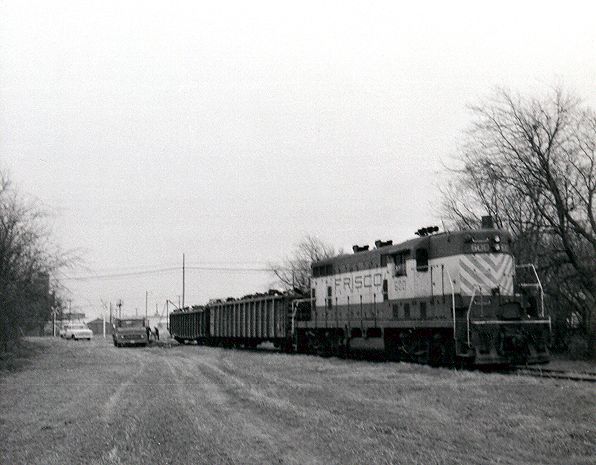
http://www.OklahomaHistory.net/ttphotos7a/ATSFHealdtonMarch1971_4.jpg5) This is a photo of a Frisco Railroad freight train, a rare sight in Ardmore. The Frisco had a branch line that ran to Ardmore from Durant and Madill. It had passenger service until 1953, with a small passenger train running daily between Ardmore and Hugo, Oklahoma. That was a distant memory however, even at the time of this photo, 1971, when the line saw little use. This train is facing south and is shown in south Ardmore. The Blue Bonnet Grain elevators are about a mile behind, and the train has just crossed Washington Ave, just south of where Washington intersects with Stanley.
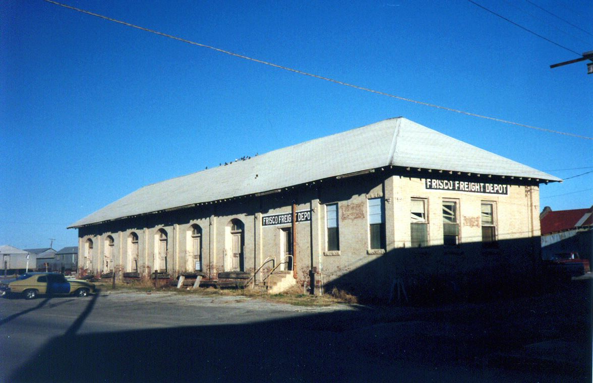
http://www.OklahomaHistory.net/ttphotos7a/SLSFFreightArdmore1971_5.jpg6) This is the Frisco Railroads' Freight Depot, shown in 1988 when I was in Ardmore for a visit several years after the Frisco abandoned its line to Ardmore. I believe the building was used by a plumbing company for awhile, but it has since been torn down. It's too bad, as it had a classic late 19th century railroad architecture style. In the extreme right side of the photo you can see the red roof of the main Ardmore depot, which serves Amtraks' Heartland Flyer.
http://www.OklahomaHistory.net/ttphotos7a/FriscoFreightDepotArdmore1988_6.jpg7) The Frisco depot was on the first street that runs parallel to the railroad tracks one block west of the existing Ardmore depot. It's been awhile so I'm struggling a little with the street name. I think it is Caddo Street, and the freight depot was on the east side of the street, just south of where it intersects with Broadway. It was torn down some time in the early 90s. I've included another pic of it from a different angle, taken at the same time as the other in 1988.
http://www.OklahomaHistory.net/ttphotos7a/FriscoFreightDepotArdmore1988_7.jpg
---------------------------------------------------------------------
Question: "Butch, Any details of the Rail Road that went thru Tishomingo and on east to somewhere, the old right of ways shows up from highway split to Madill and hiway east to Tish., I don't find it listed shown on maps I have, The right of way shows in north part of Tish.... another right of way vanishing is the old line to Ringling , and the line from Chickasha to Pauls Valley... during 20-30's'' it was the "broomcorn special" with a Doodlebug gas passenger motorcar........... old RW 's areas are nostalgic items for me with the cuts, relic telegraph poles (that's left) and sometimes a relic trestle..... good painting subjects."Answer: "The line that went through Tishomingo was the Chicago, Rock Island, and Pacific (aka "Rock Island"), and was built off their mainline that ran from Memphis through Oklahoma City to New Mexico. The line you're asking about left that mainline at Wilburton and went SW through Tish, Russett, and Mannsville to Ardmore. The plan at the time was to continue on west to Waurika to connect with another Rock Island line, but that company never built farther west than Ardmore. A different railroad built the line to Healdton and Ringling. The Rock Island line never did well and was mostly abandoned in about 1940. The last few miles into Ardmore were sold to the Saint Louis and San Francisco Railroad (aka "Frisco") which also had a line running into Ardmore from the east, from Durant and Madill. The two railroads up to that time had shared the track for those last few miles into Ardmore, and the Frisco acquired complete ownership of it. That line lasted until I think 1976. That old right of way shows up in the terrain in some places too. If you know where the railroad depot in Ardmore is, there's a little bit of history there that few people know about. On the opposite side of the depot from where the current train tracks are is another door into the stations' old waiting room. Over that door is the corporate herald of the Rock Island Railroad cast in concrete, a railroad that has been gone since before WWII, so long most people in Ardmore have no memory of it.
-------------------------------------------------------------------------
-------------------------------------------------------------------------Some mail from this week's MAILBAG.....
Hey Butch, hope you and the Mrs are well stocked for the huge snow apocalypse. Was reading your list of grocery stores and remembering back when I was a youngen in the early 50’s, there were two grocery stores next to each other on A St NE where the small antique store now is. One was ran by Mr. Benham and the other by Mr. Charles Brown. I had an older brother who worked for Mr. Brown. I may have mentioned these stores to you before, but can’t remember for sure. Take care of yourself. -Bill Holder
http://www.oklahomahistory.net/grocers.html
-----------------------------------------------
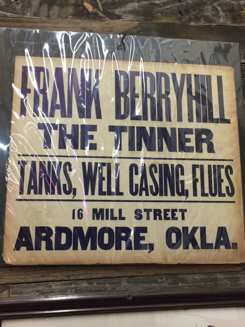
Butch, Rome and I saw this sign in an antique shop in Bixby... just had to take a picture and send it to you. Sorry for the shine, but it was in plastic. -Lisa & Rome Ingle
http://www.oklahomahistory.net/ttphotos20a/FrankBerryhillPoster.jpg
-----------------------------------------------
I have never seen any other years than these three Lake Murray boat permits. I suppose the different shapes allowed enforcement to tell if you had current boat tag without have to get to close and spoil your fishing. -Steven Harris
http://www.oklahomahistory.net/ttphotos20a/LakeMurrayBoatPermits.jpg
-----------------------------------------------
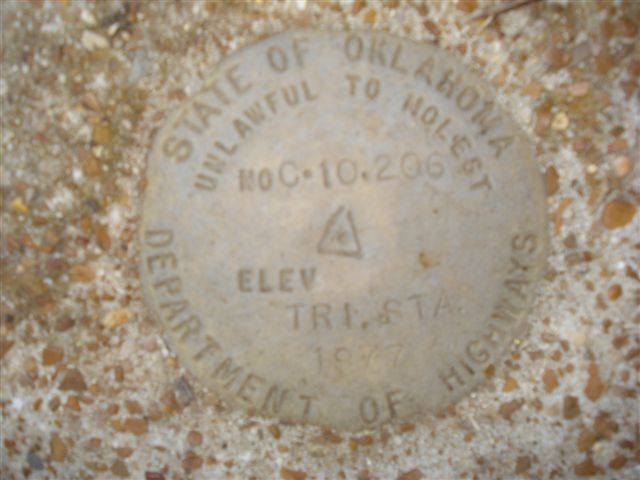
Q: Butch, If I am correct I believe the marker on Doug's property, presuming he lives on the curve east of P on 3rd Street, is something to do with elevation. I was told, and maybe mistakenly, that the hill there is the highest elevation in Carter County. Which would be difficult to believe but you can certainly see far north from there. Hope this is some sort of help. -RhettA: Doug's marker is a survey marker used as a beginning point to find a location to note for some purpose such as a sale, a construction site or old historical sites. Supposedly but never always, this marker was measured at a specific distance above sea level number recorded in the mapping archives and expected to never change. I wouldn't be a bit surprised if that marker was placed at the corner of a township or some similar expected location. -Thal
"It is a USGS survey marker with the elevation." -Doug Williams
http://www.oklahomahistory.net/ttphotos8a/WilliamsGeoMarker.jpg
-----------------------------------------------
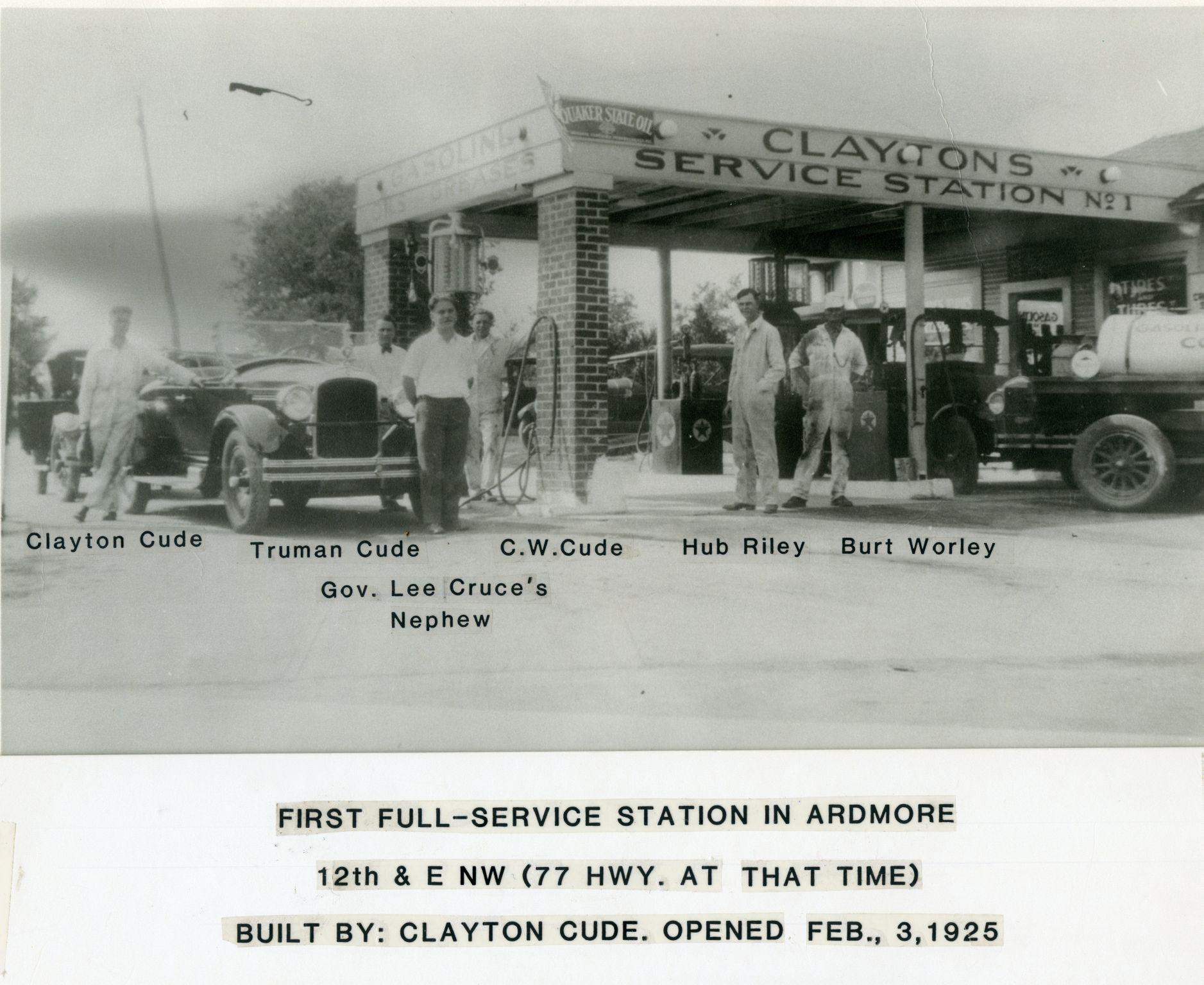
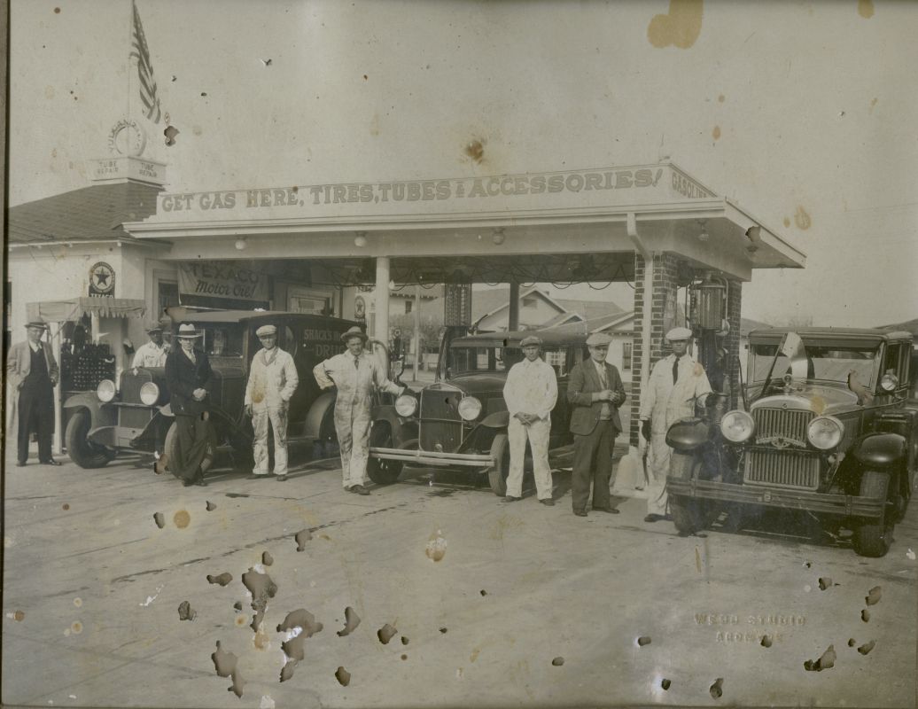
The attached photo is probably a companion photo of one that was in the Jan 23rd newsletter. Mr. Cude's daughter, Betty Sue Clark, came by with it and allowed me to scan it and send it to you. All in the photo are named, and description and date are given below. She told me the station was at the intersection of E Street and 12th Avenue NW, on the Southwest corner. (Not on South Commerce, which came later). Maybe this will shed more light on the previously submitted photo. -Steve Douglas.
http://www.oklahomahistory.net/ttphotos20a/CWCudeStation1925.jpghttp://www.oklahomahistory.net/ttphotos20a/CudeFillingStation.jpg
-----------------------------------------------
-----------------------------------------------Life is like a blanket of snow. Be careful how you step on it. Every step will show!
See everyone next week!
Butch and Jill Bridges
"Friends Make Life Worth Living"PO Box 2
Lone Grove, Oklahoma 73443http://www.OklahomaHistory.netSubscribe to T&T Newsletter
Vicious Dog Attacks in Oklahoma
http://www.oklahomahistory.net/viciousdogs.html
Oklahoma Bells: http://www.OklahomaHistory.net/bellpage.html
Bill Hamm's Cemetery Database
http://www.usgwarchives.net/ok/carter/cartercm.htm
American Flyers Memorial Fund - Administration Webpage
http://www.OklahomaHistory.net/crash66.html
Ardmore Army Air Field/Ardmore Air Force Website
http://www.OklahomaHistory.net/airbase/
Carter County Government Website
http://cartercountyok.us
All previous issues of This & That can be found on my Website's archives.
Feel free to forward this free newsletter. Mailouts: over 1,400.
To be removed from my T&T mailings, just send me an email.
I do not sell, trade or give my mailing list to anyone for any reason.