This and That Newsletter
www.OklahomaHistory.net
Vol 25 Issue 1,294 Circulation 5,000 November 11, 2021
Ardmore, Oklahoma
My email address: butchbridges@oklahomahistory.net
580-490-6823"What we have done for ourselves alone dies with us,
What we have done for others and the world remains and is immortal."
A Glimpse Into The Past
The Daily Ardmoreite
June 19, 1918
CARTER COUNTY IS SOON TO HAVE FIRST RURAL ROUTE
Carter County is soon to have its first rural free delivery mail route, Postmaster C. L. Byrne to whom the matter was referred by the department, having gone over it a few days ago and given it his hearty approval. This means the beginning of a new epoch of development throughout this section as no one thing tends to the upbuilding of the country more than a rural mail delivery.The route to be established covers a distance of 32 miles from its starting point to the same point on the return trip. The delivery of mail will begin just as soon as the city carrier limits at the Santa Fe tracks on 10th street northeast is passed. IT will then follow the mail road till the east and west road going to Chickasaw lake is reached, when it will proceed to the first left hand turn after passing the Clinton school, a distance of 8 miles from the starting point.
The road will be followed as it angles to the northwest through Mulkey, around to an intersection with th4e main road to Sulphur 4 miles from Berwyn, when it will follow the pike road west to Berwyn along the east side of the Santa Fe tracks to the south end of that town, where it will take newly improved Berwyn road and proceed in a southerly direction till near the Hignight school, when a turn will be made, the road past the Pruitt ranch and the Chickasaw Lake Club being taken. A new road is to be opened up next month by the county commissioners to the refineries, but until this road is finished the main Berwyn road will be followed into Ardmore.
The route goes through one of the best cultivated districts in the county and at this time follows the longest stretch of well built highway in the whole county. More than 300 families comprising over 1,200 people will be served by the route, making it an exceptionally good one.
When it is considered that Love, Marshall, Murray, Johnston, Garvin, Stephens and Jefferson counties all touching Carter County, have enjoyed the benefits of rural delivery for a long time, Carter County is to be congratulated on the approval of this route, as it will mean that several more will be petitioned for within a few weeks, as the work of improving the roads of the county is going on rapidly, thus removing what was previously been the principal obstacle to the securing of rural delivery.What the free delivery of farmers' mail means in a monetary way may be judged by the Pottawatomie County, where 32 routes are in operation. Land in that county ranks with the land back in Illinois, much of it being valued at $150 to $300 per acre. The presence of these routes also insures the keeping up of the roads, all of the main highways of the county being well improved. Carter County is being rapidly developed along agricultural as well as other lines and there is very reason why every town of consequence should have one or more rural routes radiating there from.
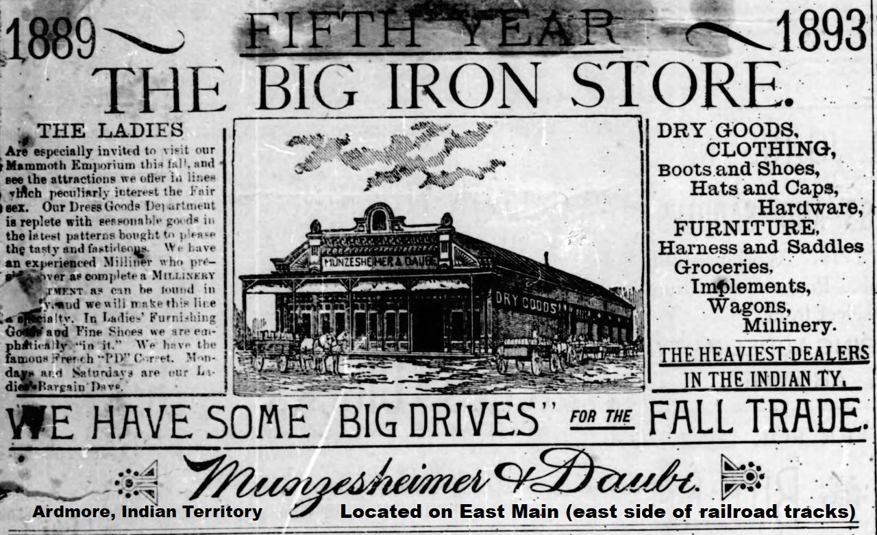
Max Munzesheimer and Sam Daube, opened a mercantile store in the spot to become downtown Ardmore. The Santa Fe railroad tracks were being laid, and the new store lay on the east side of those tracks (where now an old furniture warehouse store used to stand.) The Munzesheimer and Daube store was called the "Iron Store" because of the iron like sheets that covered the exterior.
When the first passenger train came into the new stop designated as Ardmore in 1887, Max Westheimer was aboard. He had just ran out of funds, and had to disembark to look for work. He found a job with the "Iron Store", he being born in the same town in Germany (Hoffenheim) as Mr. Daube. In 1888, Max Westheimer, in partnership with Frank Wymore, crossed the new tracks to the west and opened a mercantile store. The store was called the Blue Front and was located were the Daube's Department store used to stand, 107 East Main.
In the early 1900s Frank Wymore sold his interest in the store to Dave Daube, a brother of Sam Daube of the "Iron Store". The store was then renamed Westheimer and Daube. A few years later the "Iron Store" closed. Sam Daube, who had established another mercantile store in Bowie, Texas became a third partner in the the Westheimer and Daube store, and the Bowie store was consolidated with the Ardmore firm. This 3-way partnership later established another store in Anadarko.
In 1915 the Westheimer and Daube store was destroyed by the Great Explosion, but was rebuilt in the same location. This store became the leading mercantile and later department store in Ardmore and Southern Oklahoma. In the initial years of operation the store carried all types of merchandise- food, seed, hardware, etc. This was the function of a mercantile store. As the city grew, the store became more specialized into the clothing and linen lines. In 1935 due to a coronary condition, Max Westheimer had to step out of the firm. It then became "Daubes", and one of Ardmore's most recognized landmarks.
http://www.oklahomahistory.net/ttphotos21b/IronStore1893.jpg
Still finding people in Oklahoma with unclaimed money. We're now over the $1.7 Million dollars. Sometimes progress is slow locating people or their kin with unclaimed insurance money at the State Treasurers office in OKC but we keep moving forward.
How long has it been since you checked your name or a family member's name? Its easy to do a search at the Oklahoma State Treasurer link below. I think every state in the union has a unclaimed property website through the respective state treasures website.
https://apps.ok.gov/unclaimed/If you have Facebook, I created a new Page called Southern Oklahoma Unclaimed Insurance Money. The only Post that will go on that page is names and towns of people we are looking for with unclaimed money;
https://www.facebook.com/South-Central-Oklahoma-Unclaimed-Insurance-Money-114246471027358
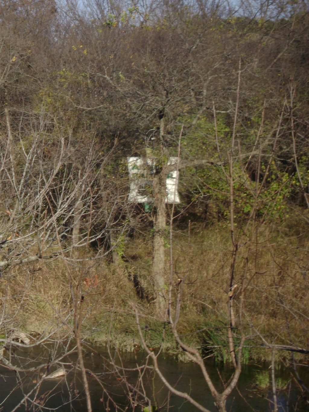
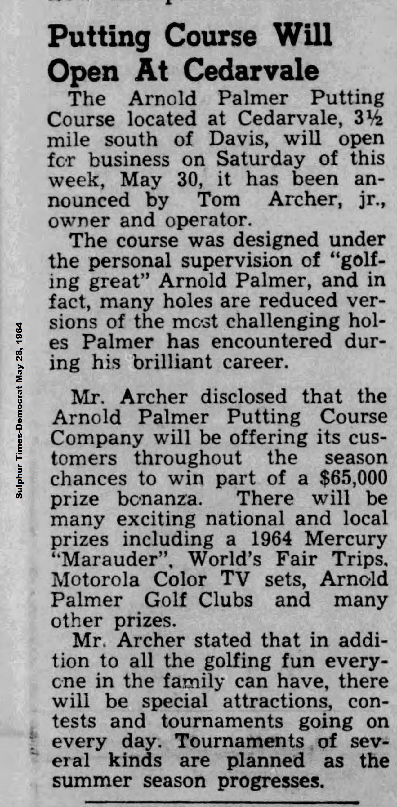
In 2009 a Reader sent the photo below of a sign south of Davis on Highway 77 just past the Fried Pie Place. He had noticed this sign on his bike rides and wondered what it was all about. One could barely see the sign from the road when some of the leaves has fallen in the Fall. On the sign it read Arnold Palmer Golf course. I did some research and found the following.
http://oklahomahistory.net/ttphotos21b/PalmerMiniGolf09a.jpg
The next two pictures tell the story of the Palmer Mini Golf course of 1964.
http://oklahomahistory.net/ttphotos21b/TurnerFallsGolf1964a.jpg
http://oklahomahistory.net/ttphotos21b/TurnerFallsGolf1964b.jpg
Q. What is Oklahoma's state grass?
A. Indian Grass
https://statesymbolsusa.org/symbol-official-item/oklahoma/state-plant/indian-grassQ. To whom did the Free Homes Bill grant free homesteads?
A. Answer in next week's newsletterSome mail from this week's MAILBAG.....
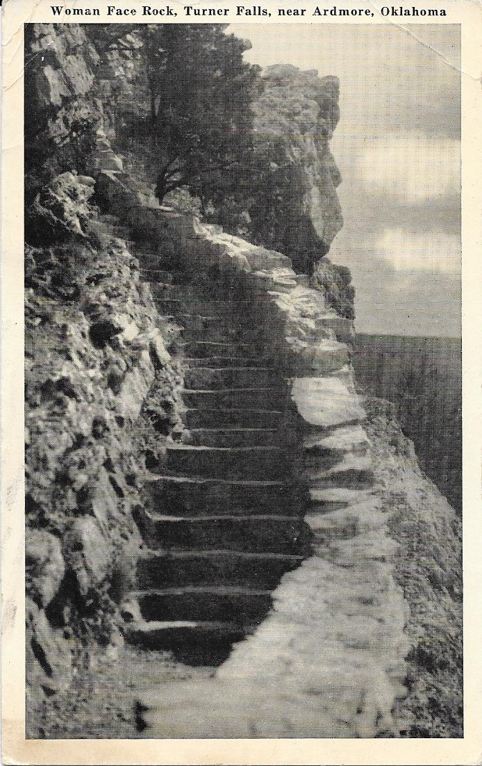
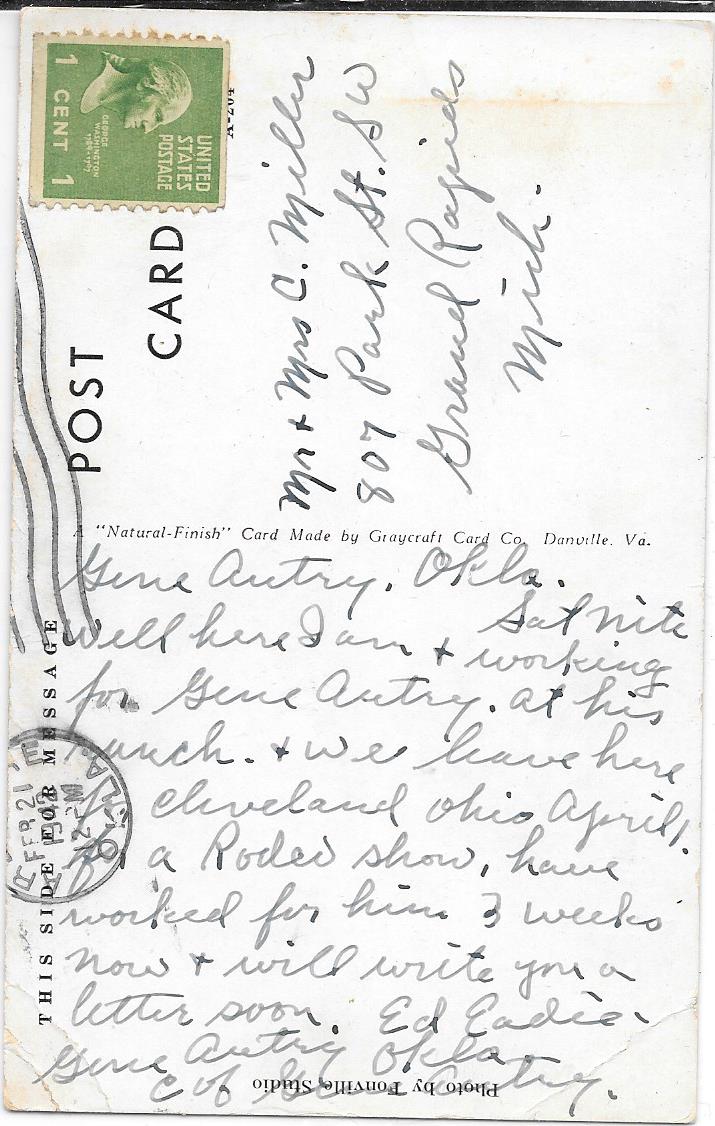
Woman's face rock at Turner Falls picture with Gene Autry ranch hand letter on reverse side of post card. -Robert Hensley
http://oklahomahistory.net/ttphotos21b/TurnerFallsWomansFaceA.jpghttp://oklahomahistory.net/ttphotos21b/TurnerFallsWomansFaceB.jpg
----------------------------------------------------------
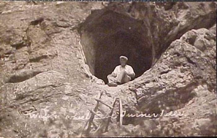
12/27/03 "Butch, about WAGON WHEEL CAVE at Turner Falls.... the one in the photo is known as CRYSTAL CAVE, located about 1/2 mile behind the current bathhouse. Wagon Wheel cave is the cave that is right next to the falls that is seen in all the photos. Outlaw cave is located on the same side, on top of the falls about 75 yards back. One of the most overlooked features in TURNER FALLS is the "Woman of the Rock" which can be seen from the castle looking up to the overlook. It is a profile of a woman's face. It used to be on the brochures listed as one of the attractions but later was dropped for some reason. Just thought I'd help clarify the Cave Names." -Bryan Pullen, Davis, Oklahoma, '32 year Turner Falls Veteran'
http://www.OklahomaHistory.net/ttphotos3b/CrystalCave.jpg
----------------------------------------------------------
----------------------------------------------------------Below is from This and That newsletter archives of November 12, 2009
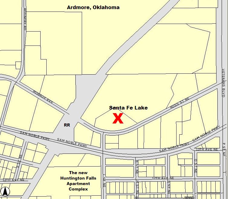
Yes, we will miss that ole trestle on G street NE. We lived in the 600 block of G street almost now a 100 years. Walked under the trestle on the way to Mama and Papa Lloyd's at the Santa Fe Lake. Rode the Dinky across it on the way to Provence, to visit Aunt Ruth and Uncle Mack and our cousins there.
The Santa Fe Lake was near the refinery. There was a manned pump station there for the steam engines to fill with water. Our Dad had the lease from the railroad on the property after the Lloyd's passed away. When our Dad died in l964, we failed to renew the lease. Someone else leased the property from the railroad and blasted the dam on the small creek running through and drained the lake and used it for pasture. It had been quite a popular fishing place for people in that area and neighborhood. The Lloyds collected a small fee for fishing there, seems like maybe 10 cents. The Lloyds were like grandparents to us. They had five children. Two lived to adult hood. Harold, a son was in the Navy. He married a girl in California. He was killed in a hunting accident there, about 1950. They had three children. His wife remarried and her husband adopted the children. I have always wondered what happened to them and where they might be??? Going down highway 70 go under the underpass on the right are some government apartments and a day care I think as we have not lived there this is as I recall visiting Ardmore. Across from these apartments etc. is an old motel two or three of the individual units are still there. There is a street going thru before P street as I remember. This street will take you over to the old highway 70 pavement that is still there......take a right and the depression on the left is where the lake was. After the tornado about 46 the Lloyd's garage was in the middle of the lake. Their house was destroyed and the neighbors and the members of the Calvary Presbyterian church on 3rd N.E. rebuilt it for them. We had Thanksgiving Dinner there that year. We had duck from the Lake. Light from kerosene lamps with wicks. The house is still there, having been updated and remodeled a number of years ago. Henry Lloyd (Papa) had worked for the railroad. As far as I can remember he had palsy. He was alert and sang for we children all the time. They had fallen on hard times as so many people of that era. Mama (Ella) Lloyd sold milk, butter, eggs and worked in homes of some of the people there in Ardmore. I can remember going to the Veterans home with her. It smelled like coffee. When I think of that home that is what I remember the smell of coffee. She was the one who introduced us to pickled chicken feet. So when visiting churches In Taiwan, a few years ago, that I relished to share this familiar delicacy with them was a happy, delightful surprise to the Saints there." fjsmathers@aol.com
http://www.oklahomahistory.net/ttphotos9a/SantaFeLake09a.jpg
-----------------------------------------------------
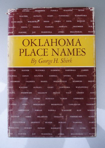
Q. How did Provence, Oklahoma get its' name?A. Provence. In Carter County, 6 miles east of Ardmore. A post office from January 4, 1895 to October 14, 1933. Named for George Provence, local merchant. -Oklahoma Place Names
George M. Provence 12 MAR 1860 - 14 MAR 1898 Buried in Provence Cemetery
https://www.findagrave.com/memorial/27885303/george-m-provence
-----------------------------------------------------
"Butch, while out riding my bicycle today I snapped a pic of the old Arnold Palmer Mini Golf place that used to be near Turner Falls. If you go towards Turner Falls from the Fried Pie shop, there is a pond on the north side of the road that used to say FEE FISHING and there is a cabin there which used to be an antique store at one time. It is directly across the road on the south side of Honey Creek. Its between the Pie shop and The Cliffs (aka Cedarvale). I have asked all around Davis and looked at the museum for photos of this place back when it was in operation. Does anyone have any of photos of it? You can still see the sign during this time of year as leaves begin to fall. Everyone in Davis remembers it being there and going there? but I have yet to find any photos. Does anyone have a photo?" -Bryan Pullen in Davis
http://www.oklahomahistory.net/ttphotos9a/PalmerMiniGolf09a.jpg
-----------------------------------------------------
"Butch, Just now took this picture of my Persimmon Tree. I have a lot of onlookers. They aren't rip yet, they have to be frozen first. Sure brings in the wildlife too." -Sam Cottrell
http://www.oklahomahistory.net/ttphotos9a/PersimmonTreeCottrell9a.jpg
-----------------------------------------------------
-----------------------------------------------------“Expect the best. Prepare for the worst. Capitalize on what comes.” -Zig Ziglar
See everyone next week!
Butch and Jill Bridges
"Friends Make Life Worth Living"
Ardmore, Oklahoma
http://www.OklahomaHistory.net
Subscribe to T&T Newsletter
Vicious Dog Attacks in Oklahoma
http://www.oklahomahistory.net/viciousdogs.html
Oklahoma Bells: http://www.OklahomaHistory.net/bellpage.html
Bill Hamm's Cemetery Database
http://www.usgwarchives.net/ok/carter/cartercm.htm
American Flyers Memorial Fund - Administration Webpage
http://www.OklahomaHistory.net/crash66.html
Ardmore Army Air Field/Ardmore Air Force Website
http://www.OklahomaHistory.net/airbase/
Carter County Government Website
http://cartercountyok.us
All previous issues of This & That can be found on my Website's archives.
Feel free to forward this free newsletter. Mailouts: over 1,300.
To be removed from my T&T mailings, just send me an email.
I do not sell, trade or give my mailing list to anyone for any reason.