
PO Box 2, Ardmore, Oklahoma 73402
Email: butchbridges@oklahomahistory.net
Phone: 580-490-6823
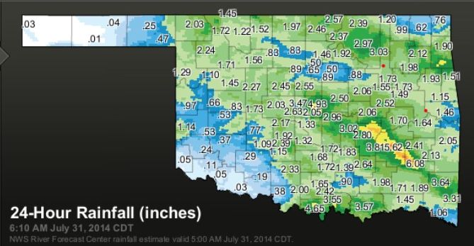
Finally. We finally got a good rain yesterday here in Carter County. www.mesonet.org shows almost 2 1/2 inches for Ardmore area. The area just west of Marietta, Oklahoma received a little over 4 1/2 inches of rain! It has still not got us out of the Exceptional Drought, but any rain helps.
https://oklahomahistory.net/ttphotos14b/OKrainfall073114.jpg
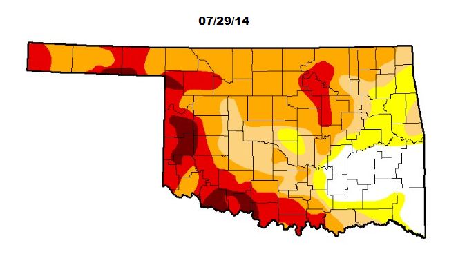
The dark brown areas are Extreme drought.
https://oklahomahistory.net/ttphotos14b/OKdrought072914.jpg
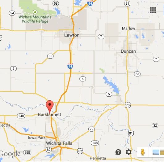
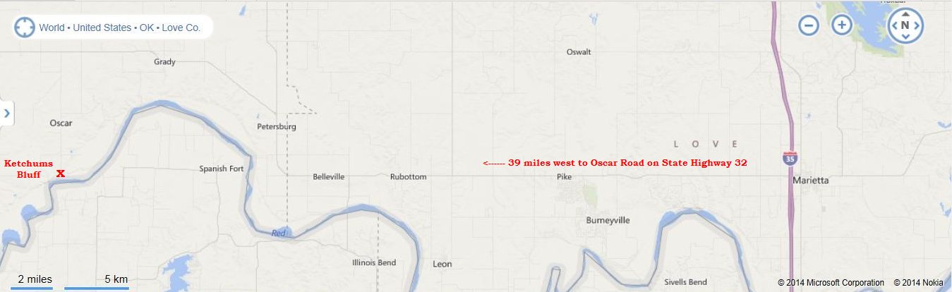
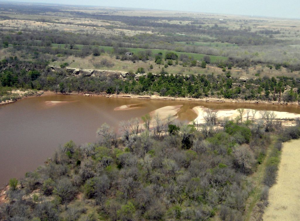
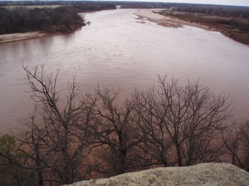
Several times over the years we have talked about an area 39 miles west of Marietta, Oklahoma along the Red River called Ketchum’s Bluff. In 2008 we traveled with some friends to that area and took photos of Ketchum’s Bluff. It is really a scenic view from atop the cliff overlooking the Red River that separates Oklahoma from Texas. Six years has past since our one and only visit to Ketchum Bluff, and this week I received an email with more history on the area along with a 1908 photo taken of a family sitting on their car on the Red River bridge between Burkburnet, Texas and Oklahoma. Below is the email I received:
Ketchum’s Bluff 1918: “My mother Nannie Louise McKown Bonham was born August 4, 1918. Her parents Euell Edward and Katy McKown and another McKown family, operated a ferry there at the time of her birth. Her brother was a little over two years old and remembered the occasion. His retelling of the story of my mother’s birth went something like this:
” The women folks got all excited and told me to get out of the house. I’d heard stories about a stork bringing a baby and right after I heard the baby crying for the first time, an airplane flew over us. I had never seen an airplane before and I wasn’t sure what a stork was at the time, so I just said, ‘an airy plane brought my baby sister.’”
Mom told me (about 1988). that for the last 70 years, she had never visited the place where she was born and that she remembered that the ferry was somewhere between Nocona and Oklahoma, on the Red River. We hastily planned our trip and headed out the next week from Crosby, Texas to Nocona. On the way, she seemed especially excited. My confidence might have puzzled her because my research didn’t reveal any clues. She asked how in the world would I find the place if it didn’t show up on any of the current maps.
“We’ll just go to the feed store in Nocona.”
I had a little experience selling metallic buildings and grain bins, and knew the value of hanging around drinking coffee at the local farm/ranch supply
To make the story a little shorter, the feed store owner had a county map on his office wall and pointed out the location. He then introduced us to a local rancher in the store who said “follow me”. After arriving at his ranch, we climbed in with him, cut through a couple farm gates and he took us to the edge of the Red River and pointed across the river at Ketchum’s Bluff. (My brother Michael Benton Bonham, was named in honor of the Benton family who lived in the Nocona area.)
The gentleman also told us how to reach the other side. After crossing the bridge and driving back to the location on the Oklahoma side, we randomly picked a home where a man was washing his pickup in the front drive. We introduced ourselves and I asked him if he knew the location of Ketchum’s Bluff. He said, yep, it was visible from his backyard overlooking the river. and invited us to take a look. When mom told him about her folks operating a ferry and her birth, he point down to the banks and said, there were some old remains of shacks at one time, but the river washed it away a long time ago.
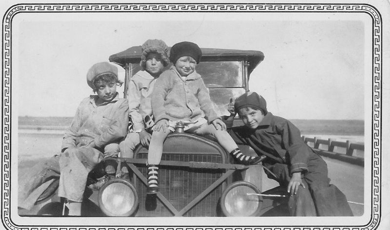
My mom lived to the ripe old age of 91 years. She was an amazing woman. Here is a 1908 photo of Louise, sister Francis, a neighbor girl (straddling the radiator cap) and sister Margarette. The car is sitting on a bridge over the Red River between Burkburnett, Texas and Oklahoma.” -David Bonham
https://oklahomahistory.net/ttphotos14b/BonhamFamily1918.jpg
Below is a map and some photos I took on our visit in 2008.
https://oklahomahistory.net/maps/KetchumBluffMap.jpg
If you paste the following in Google Maps it will take you right to the area.
33.9375, -97.7551
https://oklahomahistory.net/ttphotos8a/KetchumBluffAerial8a.jpg
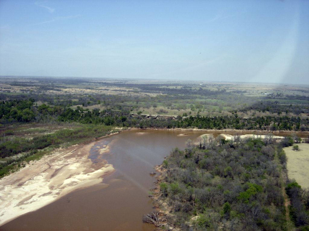
https://oklahomahistory.net/ttphotos8a/KetchumBluffAerial8b.jpg
https://oklahomahistory.net/ttphotos8a/KetchumBluff8a.jpg
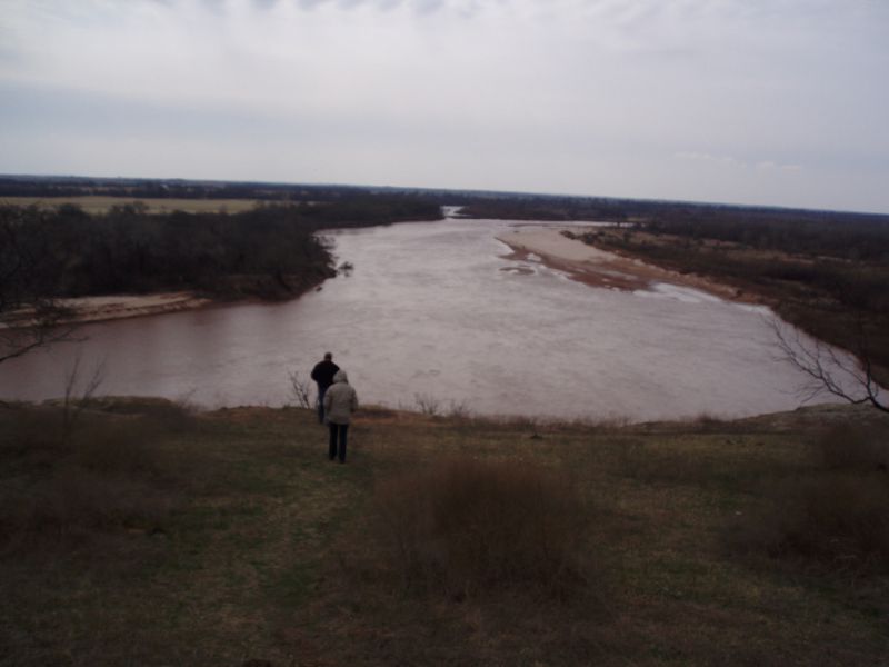
https://oklahomahistory.net/ttphotos8a/KetchumBluff8b.jpg
By the way, I am still looking for the origin of the name Ketchum’s Bluff. Maybe someone out there knows.
I’ve spoken about the Colston Building several times the past few years. In September 2006 I took pictures of their old electric generators in the basement, and the still working water pressure driven service elevator in the basement too. But this week I learned the water pressure driven service elevator quit working since I took photos of it in 2006. It always make saddens me a little when I learn such an old 1917 piece of Ardmore history has fallen by the wayside. Maybe some how, some way, some day it can be fixed.
https://oklahomahistory.net/ttphotos/colstone.jpg
https://oklahomahistory.net/ttphotos/watrlift.jpg
https://oklahomahistory.net/ttphotos/waterval.
https://oklahomahistory.net/ttphotos14b/ServiceElevator07311b.jpg
https://oklahomahistory.net/ttphotos14b/ServiceElevator07311a.jpg
The Ardmoreite, July 1930
The crash of the bank at Sulphur was one of the most complete failures in the history of the state. Eugene White, former cashier, last week was released from the penitentiary where he served 18 months after conviction on a charge of receiving deposits in an insolvent bank. The General Finance and Sales Company gave $1,800 for the $220,122 in assets.
The Ardmoreite, July 1930
Charles E. Byrd, who is running for sheriff, is known as the Lone Grove candidate and he has the solid backing of the people in his home community, but, as pointed out recently, he lives in Ardmore, and bought a home there some six months ago.
The Ardmoreite, July 1954
Robert Denney and Gene Meadows will face off in a runoff election in August for the job as Lone Grove Constable.
The Ardmoreite, July 1986
Callahan Road residents gave $5,400 to the City of Lone Grove to pay the County to pave their road. The Callahan project has been on the burner for over a year.
The Ardmoreite, July 1986
The Time Capsule in Lone Grove’s Sullivan Kiwanis Family Park was vandalized. A fund has been established with a $1,000 reward leading to the arrest and conviction of the vandals.
This week I decided to do something different on my Facebook. I posted a photo with two toilet paper holders side by side. One had the paper rolling off from the back, the other from the front. I asked my 5,000 facebookers to vote on which they preferred. With over 900 responding with their preference, overwhelmingly they replied, off the front of the roll.
https://oklahomahistory.net/ttphotos14b/ToiletPaperVote.jpg
Doug Williams bought a GoPro video recorder the other day and has mounted it on his motorcycle. Below is a link to a recording he made while touring his hometown of Gene Autry, Oklahoma with the camera running.
http://winterfamily.smugmug.com/Bike-ride-through-Gene-Autry/
I’ve been trying to determine exactly where Staunton, Oklahoma was located in Carter County. I have seen it reported to be in SW Carter County and in the NW part of the county north and west of Healdton. Maybe some old timers out there remembers?
Q. Just outside Pauls Valley, Oklahoma in 2012 a film crew shot part of a movie in a nearly 100 year old 2-story house. What was the name of that movie?
A. The Oklahoma produced movie Yellow was released in 2012.
http://www.yellowthefilm.com/
http://anaifeh.smugmug.com/AOCHOMESSCOUT/Kemper-Yellow-Home/i-5QVPpQZ
Q. Tornado was billed as the “unrideable” bull and had thrown over 200 riders in a 14 year period before being rode those 8 seconds by a bull rider from Soper, Oklahoma. Who was that bull rider?
A. (answer in next week’s T&T)
Oklahoma’s first state regulated oil field was at Healdton, Oklahoma.
http://www.okmoga.com/html/tour_details.php
From This and That newsletter archives of July 15, 2000:
I got a pic of that bell out on Burns Road, SW of Ardmore. It’s Owner, Roscoe Campbell told me he obtained the bell in 1949 while working on an oil lease near Lindsey, Oklahoma. It’s owner in 1949 was about 80 years old and told Mr. Campbell his mother called him with this bell when he was a kid. He said if Mr. Campbell would promise to keep the bell forever, he’d let him have it free of charge! So to this day its in his front yard on Burns Road SW of Ardmore.
https://oklahomahistory.net/bellphotos/bellcamp.jpg
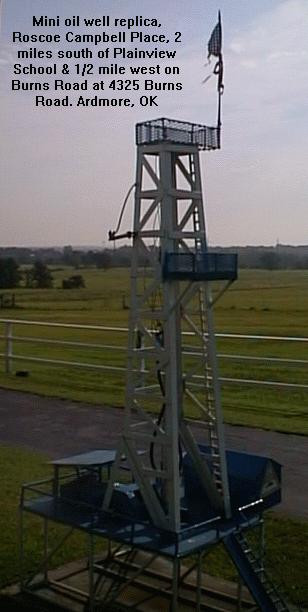
Also in Mr. Roscoe Campbell’s front yard was a mini oil well he built out of scrap iron. Pretty neat.
https://oklahomahistory.net/ttphotos14b/miniwell.jpg
—————————————————-
I was over in the NE part of Ardmore this week and noticed the old Hunt’s Grocery was closed down. They said it closed down about May of this year (2000). It’s original owner was Herman Hunt, Sr. Herman also built and owned the old “Hilltop” grocery at Wallace and Chickasaw Blvd when he was a young man. He ran both groceries for about two years, then only operated the one on 3rd NE until his death in 1971.
https://oklahomahistory.net/ttphotos14b/HuntsGrocery1999.jpg
—————————————————-
That digital camera donated last week by Bill Dixon in Healdton, OK went for $78 on eBay! The $78 will be placed in the American Flyers Memorial Fund showing Bill Dixon as the donor of the money.
—————————————————-
“I just talked to my mom on the phone. She grew up in N.E. Ardmore, and recalls the old brick yard. She says it was located north of 7th N.E. on the west side of the train tracks. We’ll see if we can come up with a picture of it.”
—————————————————-
“Something you might want to check out. Out near Gene Autry there is a house made of old tires. It was built by Dale Dixon and his wife. Dale would more than likely let you take pictures of it to share with your readers. They did and excellent job on it and it is recycling at best, plus energy saver.”
—————————————————-
“Butch, I was reading my book (“Ghost Towns of Oklahoma” by John W. Morris) and spotted an interesting little town in your neck of the woods. The name of the town is Woodford (a.k.a. Bywater), Sec. 34, T2S, R1W, 11-1/2 miles north, 9 miles west of Ardmore. According to this book that was written in 1975, Woodford (Bywater) had a Post Office from February 4, 1884 thru November 22, 1974.”
—————————————————-
—————————————————–
Gas prices today in the Ardmore area……
http://www.oklahomagasprices.com/index.aspx?mss=152754
Check gas prices by town or zip code anywhere in U.S.
http://www.kmov.com/traffic/gas-buddy
Non-ethanol gas (pure gas) stations in the Ardmore area.
https://oklahomahistory.net/puregas.html
Some mail from this week’s MAILBAG…..“Butch, The newspaper article was a photo with caption showing Cecil York and Dr. Sherman Lawton examining the canoe at the York residence in Ardmore. The library’s newspaper copy was on microfilm and very dark so it was not reproducible. When I last visited the Ardmore Public Library, the librarian was in the process of re-cataloging the McGalliard photo collection and could not find a print or negative used by the newspaper.
This is a fascinating story involving a 1930s movie made by the WPA as part of an early effort to save the Spiro Mounds from total destruction. Upon completion of the movie, the canoe went to the OU Museum, then ended up at the OU Biological Station at Willis (Lake Texoma) where it was lost in the lake. It was caught on a lure with rod and reel by the Yorks while fishing and subsequently taken to Cecil’s home in Ardmore. Tom York lived across the street from me in Duncan ten years later when I first heard about it.
After an exhaustive search of regional museums pertaining to generic specimens of dugouts, I discovered that one was missing from the OU Museum in Norman. When I reviewed the WPA film and positively ID the canoe, I donated it to the Spiro Mounds Archeological Park. Last year Tom visited the park / museum to see the canoe and discovered that all historical data had been lost regarding the acquisition of the canoe due to the transfer of the park / museum from the Oklahoma Parks & Tourism Dept to the Oklahoma Historical Society. I had to provide copies of my documents back to the state in this matter.
Any information would be helpful. Thanks.”-Towana
Butch, Someone mentioned Ice Docks a week or two ago. Here is my experience in the Ice Industry.
?I WAS THEIR ICE MAN?. In 1943 after I finished the 10th grade at Orr High School in Love County I went to Gainesville, Tx. that Summer and drove an Ice Truck. It was an old pickup truck loaded with huge blocks of ice covered and wrapped with heavy tarp to prevent melting. I would drive up to each house and look for the sign in the window telling me how many pounds of ice they wanted that day. After chipping it off of the big block, I would go in the kitchen door, which was left open for me and put it in the ?Ice Box?, then, I would look on top of the ice box for their book of tickets. I would tear out the amount of tickets to pay for their ice that day and be on my way to the next house. ( Lot?s Of Trust Back Then). I worked primarily at Camp House when the Army Base was there.” -Edgar Wallace
re: Ben Carter Collins and Jim Miller
“Butch, I sent you an article about Jim Miller Assassin. There are several online including pictures. If you google him that will provide more info about this psychopath than you ever wanted to know.
I became aware of him years ago when I was doing research for a book. There is an out of print book about him called “Shotgun For Hire”, but you can get a copy with a little effort. When he wasn’t killing people for money he gave the outward appearance of being very religious and an active Methodist in the Fort Worth Church.
My research was about the Heald Family. Of course Charles Hobart Heald (CHH) is the guy Healdton was named after after originally being called Mason. Marshal Ben Collins married CHH’s daughter Hettie Bernard Heald. Both were regarded as Indians. If memory serves, they lived near Nida a town that Lake Texoma eventually covered. Rather than being on his porch on the fateful day, he may have been coming thru the gate to his property about 200 yards away when he was ambushed and killed. Hettie was on the porch and heard Miller’s shotgun blast.
Miller was not convicted of the homicide. He did not try to escape, but turned himself in. He used the tactic of turning himself in and then getting the best lawyer money could buy. The legal system in Oklahoma was in it’s infancy and the bad guys often “got away with murder”. It worked more than once for him, but not in Ada. By this time folks new the score and took things into their own hands. He and 3 other bad guys were taken to a stable next door to the police station and hung.Hettie Heald Collins eventually remarried Rufus Davis and lived in northwest Ardmore. I believe the house was on or near 12th Avenue….it’s a large place and still there.” -Barry Flanery
“The Chicken Coop Manual is a comprehensive, well-organized collection of all the lessons we?ve learned along the way about coop layout, design, materials and operation. In the book, we cover all these concepts and practices, and describe the elements which can be varied versus the elements which need to be provided regardless of size, location or climate. We answer all the questions we?ve been asked over the years. Our goal is to help folks build safe, durable, efficient, clean and attractive coops, whether the coop is for a few backyard birds, a small homestead flock, or a small-scale commercial operation.” -Kathryn Kerby, Owner, Frog Chorus Farm http://www.frogchorusfarm.com/ChickenCoopManual.html
https://oklahomahistory.net/ttphotos14b/ChickenCoopManualDesc.html
Remember, we are shaped and fashioned by what we love.
See everyone next week!
Butch and Jill Bridges
Nashobish Ikana
PO Box 2
Lone Grove, Oklahoma 73443

Vicious Dog Attacks in Oklahoma
https://oklahomahistory.net/viciousdogs.html
Bells of Oklahoma
https://oklahomahistory.net/bellpage.html
Carter County Courthouse Paver Project
http://www.brightok.net/cartercounty/pavers
Save on long distance calls, just a couple cents a minute!
http://www.CheapLongDistance.org
Ardmore High School Criterions Online
http://www.ArdmoreCriterion.com/
Oklahoma Bells: https://oklahomahistory.net/bellpage.html
American Flyers Memorial Fund – Administration Webpage
https://oklahomahistory.net/crash66.html
Official American Flyers Memorial Website
http://www.brightok.net/~wwwafm
Ardmore Army Air Field/Ardmore Air Force Base Website
http://www.brightok.net/~gsimmons
Mirror Site of the Ardmore Army Air Field/Ardmore Air Force Website
https://oklahomahistory.net/airbase/
Carter county schools, past and present
http://community.webshots.com/user/oklahomahistory
Carter County Government Website
http://www.brightok.net/cartercounty/
All previous issues of This & That can be found on my Website.
Feel free to forward this free newsletter. Mailouts: over 1,600.
To be removed from my T&T mailings, just send me an email.
I do not sell, trade or give my mailing list to anyone for any reason.