
PO Box 2, Ardmore, Oklahoma 73402
Email: butchbridges@oklahomahistory.net, Phone: 580-490-6823
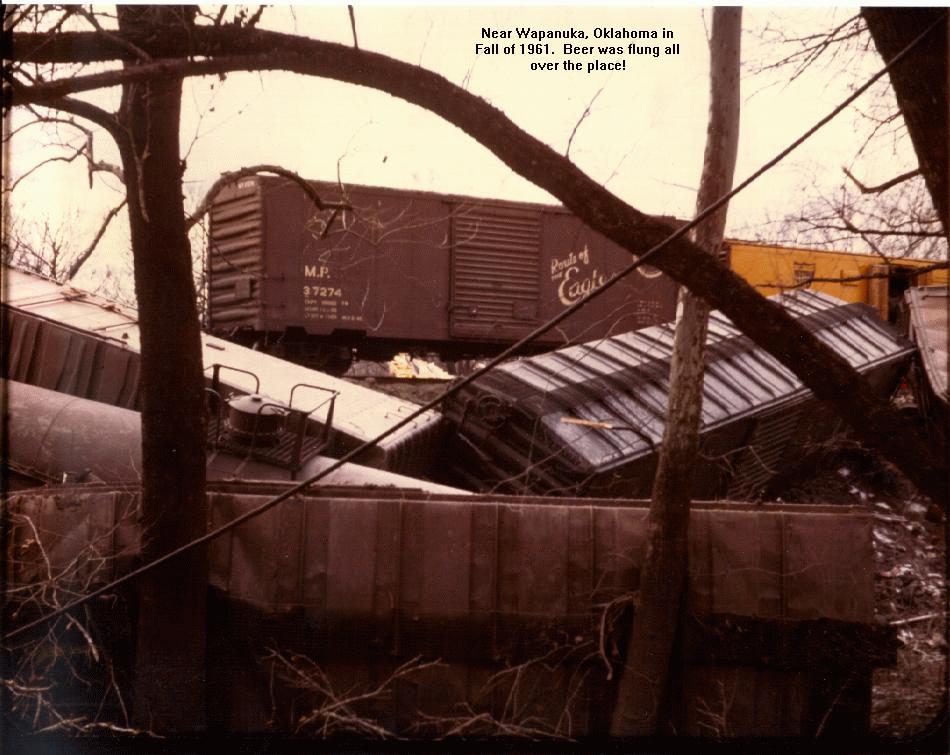
A few years ago I posted in my newsletter about a train wreck at Wapanuka. I asked if anyone knew of this incident and the Texas Schlitz beer that was scattered all over the tracks. Everyone said the accident happened in the Fall of 1961. A resident of the Wapanuka, OK area who has been gone from Oklahoma for 30 years (now in Oregon) had a photo of this infamous train wreck. Here it is, a one and only photo! A glimpse into the past!
https://oklahomahistory.net/ttphotos7a/WapanukaTrainWreck.jpgJanuary 1934
Zeb Crawley, 45 a farmer living in the Glenn community, was instantly killed in a wreck last night. Crawley is survived by his widow and five children. The driver of the other car, Andrew Walker, was on his way to Dundee where his wife is a teacher. There was no lights on the Crawley’s vehicle a 1934 Chevrolet.January 1934
Doctor W. G. Hathaway of Lone Grove was elected vice president of the Carter County Medical Society at a meeting which was held to also discuss the presence of diphtheria in the county.January 1958
The Carter County Jail and Sheriff’s Department are without funds to feed prisoners and pay mileage for police work in the county. The discovery that funds were not available was made when the County Commissioners checked a $761 mileage claim filed by Sheriff Enoch Watterson. All that was left was $185. It was pointed out that by Commissioners that according to the law no supplement can be paid until 90% of the County taxes are paid. That is not expected to occur until March.January 2003
The Closet Ministry was opened by Sandra Newman. Other local residents helping with the operation include Clara Idleman, Julie Fay Dougherty, Susan Conway and Carolyn Norton.You can find current gas prices for a particular Oklahoma town by entering the name or zip code in the GasBuddy search box.
http://www.oklahomagasprices.com/
Q. Where is the oldest bar in Oklahoma?
A. Okarche, Oklahoma http://eischensbar.com/
Q. What Oklahoman invented the pressurized suit that would make high altitude flights possible.
A. Answer in next week’s newsletterBelow is from This and That newsletter archives of February 22, 2006
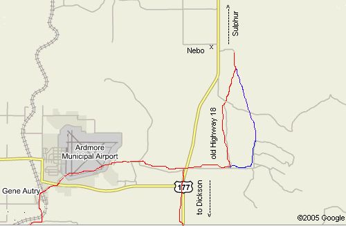
This week I had a great conversation with Ralph Stewart. Ralph is 81 years young and raised at Dickson, OK, but moved to California after high school. He returned a few years ago and is now living outside Oklahoma City. During our phone conversation there were a couple of things that really caught my attention. I know some of you will remember Highway 177 that runs between Dickson and Sulphur was not always 177. Back in the 60s I remember it being Highway 18. It actually started just a couple hundred yards east of the present Highway 199 and Highway 177 intersection at Dickson. Back in the 60s when I was a teen old Highway 18 started between the Dickson elementary and high school, and went north about 1/2 mile and then intersecting with what is now 177 North.
But what really peeked my interest is when Ralph told about the old Highway 18 turned east at the Goddard Barn (south edge of the Arbuckle Mts) continuing east a mile or two and then angled back north through the mountains coming out about a 1/2 mile south of Nebo at the now highway 177. About the only thing left of Nebo, Oklahoma is the old Nebo store, which is on the verge of falling down.
Ralph told me you can see where the old Highway 18 took off to the east when you get on top of a “bald hill” just south of the Nebo store. Of course now there is a fence there on the east side of Highway 177, but you can still see where the old highway angled off to the east. I have drawn a red line how I believe the old highway 18 went east of the Goddard Barn. Since it looks like two ‘roads’ that go off the the north through the Arbuckle mountains, I drew a blue line to show that second ‘road’. Maybe someone knows which one is the correct road north?
https://oklahomahistory.net/maps/Highway18North.jpg
You will also notice in the above map where I continued drawing the red line east of Goddard Barn to come in to the back side of the Airpark. That road used to be Young Road, not sure what it is now. It ends at the Washita river on the east side of the Airpark where the bridge is out. You can see it continued on in a southwestwardly direction and coming in to Gene Autry at the north railroad track crossing. As you go across the railroad crossing at the north end of Gene Autry, the road continued straight east and did not immediately curve back to the north as it does today.
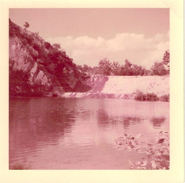
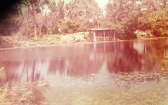
Now the other interesting piece of history from Ralph: Has anyone heard of Oil Creek Falls in eastern Carter county? He said it was east of the Goddard Barn and back north into the Arbuckle Mountains. He said the water came of the falls, then over another big rock and splashing to a deep swimming hole. Ralph said the falls was a popular place during the late 1930s. Wish someone had a pic of Oil Creek Falls.
Update: Oil Creek Falls. https://oklahomahistory.net/ttphotos6a/OilCreekFalls6a.jpg
————————————————————————
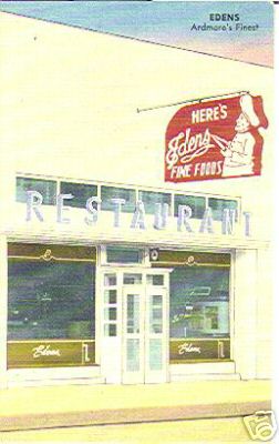
Here’s a pic of the old Eden’s Restaurant that was located next door to the old Tivoli theater on Main Street when I was a teen.
https://oklahomahistory.net/ttphotos6a/Edens1945.jpg
————————————————————————
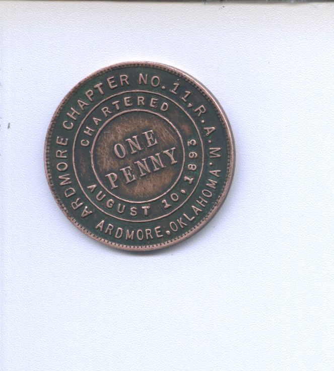
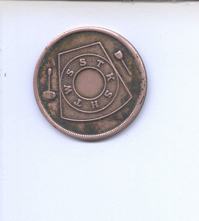
James Watkins brought by a coin this week he found when cleaning out his floor furnace. After doing some searches in google and ebay, I found out it as produced for the Masons. This particular coin was made in 1893 and is in great condition with lots of detail to be so old. On one side is: “Ardmore Chapter 11, R.A.M Charted August 10, 1893 Ardmore, Oklahoma”. The letters R.A.M. stands for Royal Arch Masonry. The coin is one Penny.
https://oklahomahistory.net/ttphotos6a/RAMcoin1.jpghttps://oklahomahistory.net/ttphotos6a/RAMcoin2.jpg
————————————————————————
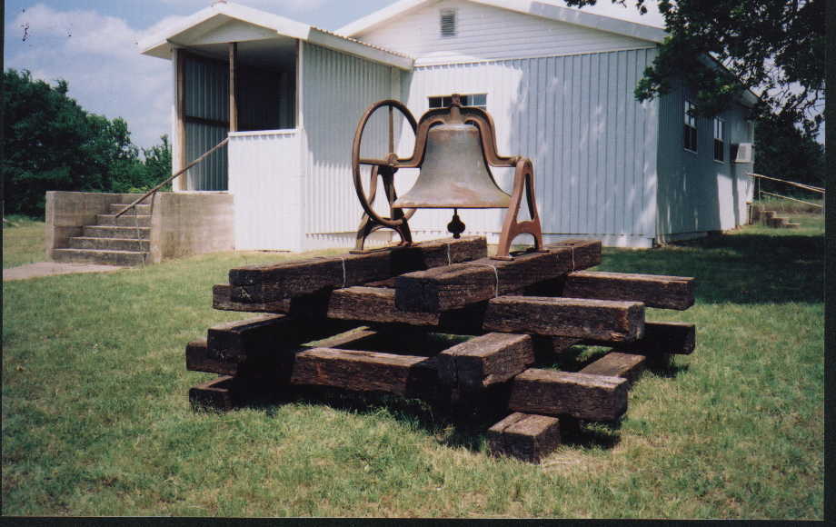
“Hi Butch, I had written you about the McMillan School Bell sometime back and you were going to try to get down & get a Picture. Don’t know if you did or not, so thought I would send you one. This Bell had been stored out in the pasture behind Arville Saxon’s home after it was removed from the School building several years ago. I had talked to Mr. Saxon about putting it out in front of the old school, now Community Center. He was in poor health & passed away before we got it done. His Son J.A. took over his Dad’s volunteer duties in the Community, so I approached him and sent him some pictures of a Bell in front of the Chisholm Trail Museum at Waurika, & I thought that would be a good way to display it. To my great surprise, last May at the McMillan Homecoming, he & his Son had installed it. I couldn’t have been more proud & I know his Dad and my Dad & Mother, Melvin & Iva (Harrell) Gardner, all started school there about 1914, would be equally proud. Butch, the is the bell that came from the McMillan School. But I know about the Tyler School Bell too. I believe a man by the name of Dall Peoples has the Tyler School Bell at his home about a mile North of the McMillan Road on Yellow Hills Road. I believe that is the correct name of the Road. Too bad it wasn’t displayed in front of the old Tyler School, which is still standing. Maybe used as a Church sometime back. My older Brother had to climb up in the belfry several times to replace the rope, while we were attending school there in the late 30’s & early 40’s. Great memories. Thanks for letting me share this information. I do so enjoy your weekly T&T’s” -Tawana (Gardner) Fleming
https://oklahomahistory.net/ttphotos6a/McMillanSchoolBellMay2005.jpg
————————————————————————
————————————————————————Some mail from this week’s MAILBAG…..
Hi Butch, recent mention of tamales in T&T brought this back —
In the 1930s a Mexican called Tony sold tamales from a push cart. We at 11th & B NW heard his yell “tamales” as he pushed by. My Mother thought his price was high but bought now & then. They were very good, each one wrapped in corn shuck & the several in newspaper. Later the story circulated he used horse meat in his tamales & he got hauled in Justice of the Peace court where he said made of rabbit, more questions brought out yes, rabbit & horse. “how much rabbit & horse” – finally “50-50, one rabbit, one horse”. -Bob McCrory
———————————————–
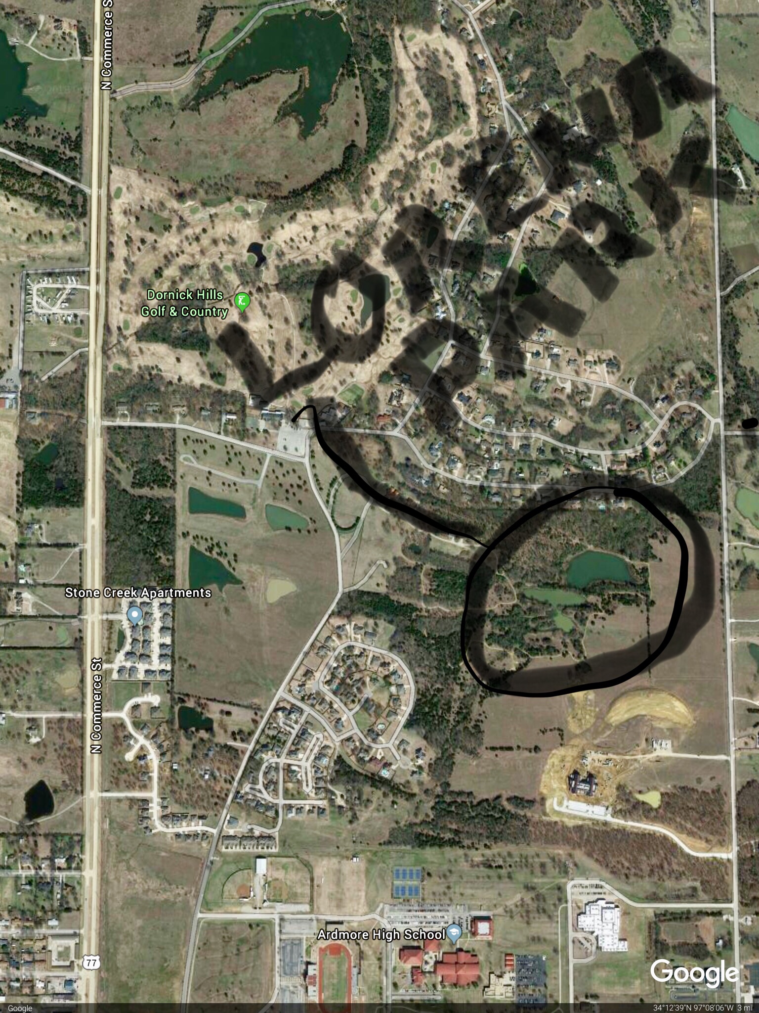
“Butch, in the 1970’s Ardmoreite reporter and historian Mac McGalliard took me and nationally recognized treasure hunter and metal detector distributor, Ken Lehman, to Lorena Park. We found several old coins and items from that era.” -Jay Roberts
https://oklahomahistory.net/ttphotos18a/LorenaPark1970s1.jpg
https://oklahomahistory.net/ttphotos18a/LorenaPark1970s2.jpg
https://oklahomahistory.net/ttphotos18a/LorenaPark1970s3.jpg
https://oklahomahistory.net/ttphotos18a/LorenaPark1970s4.jpg
https://oklahomahistory.net/ttphotos18a/LorenaPark1970s5.jpg
———————————————–
Before the City bus began turning South at I Street and 3rd NE. It went all the way west to F Street NE before turning South. They were able to pick up more black ladies who were maids in the SW part of town by changing to turn South on I Street. I will see if I can find out the hot tamale man’s name. The one who told me years back is now gone. -Larry
———————————————–
Everybody says they want to be free. Take the train off the tracks and it’s free-but it can’t go anywhere. -Zig Ziglar
https://en.wikipedia.org/wiki/Zig_Ziglar
———————————————–
———————————————–Butch and Jill Bridges
“Friends Make Life Worth Living”PO Box 2
Lone Grove, Oklahoma 73443
Vicious Dog Attacks in Oklahoma
https://oklahomahistory.net/viciousdogs.html
Oklahoma Bells: https://oklahomahistory.net/bellpage.html
Bill Hamm’s Cemetery Database
http://www.usgwarchives.net/ok/carter/cartercm.htm
American Flyers Memorial Fund – Administration Webpage
https://oklahomahistory.net/crash66.html
Official American Flyers Memorial Website
http://www.brightok.net/~wwwafm
Ardmore Army Air Field/Ardmore Air Force Base Website
http://www.brightok.net/~gsimmons
Mirror Site of the Ardmore Army Air Field/Ardmore Air Force Website
https://oklahomahistory.net/airbase/
Carter County Government Website
http://cartercountyok.us