
We haven’t been to Enos (south of Madill) by Lake Texoma in over 10 years. Enos is 15 miles south of Madill. Its just a wee little town, but I’ve heard its grown like a weed the past few years and no longer a wee little hamlet. And it has a great place to eat called Ollie’s Restaurant.
THE ENOS GAS FIELD
submitted by: Jimmy Bishop, Enos, OklahomaSoon after statehood commercial production of oil and gas began. The Madill Pool generated 540 barrels of oil daily in 1929. The Enos Gas Field near Kingston attracted a number of early drillers. In 1940 the Pure Oil Company established an oil camp that at its peak comprised forty-three houses and a thirty-five-bed bunkhouse. The camp and a nearby Warren Petroleum gas plant supported the town of Little City, originally named Pure City. The camp and town suffered damage from a 1957 tornado, and although the people rebuilt the two, the Pure Oil Company closed the camp in 1959. In 1975 county wells produced 858,675 barrels of oil and 5,849,037 million cubic feet (mcf) of natural gas. In 2000 production comprised 170,582 barrels of oil and 3,993,760 mcf. Local limestone (404,310 tons in 2002) and sand and gravel (2,587 tons) have also been commercially extracted.
Until petroleum was discovered in the early twentieth century, agriculture was the principal income-producing pursuit. Ranching has played a key role in the region’s economy. Prior to allotment, early prominent cattlemen included George Holford, William and Dorsey Taliaferro, James Hamilton Willis, and Richard Wiggs. In 1907 the county contained 8,333 cattle and milk cows, a number that increased to 18,631 in 1935. By 1963 ranchers ran 32,000 head of cattle. In 2000 the total of milk cows and cattle was twenty thousand. Farming in the Red and Washita river valleys also contributed to the area’s prosperity. In 1907 cotton (36,449 acres) and corn (34,035 acres) dominated. In 1934 most of the 1,476 farms still planted cotton (20,671 acres), with corn (18,508) and oats (14,589) second and third. By 1963 farmers had lost valuable land to Lake Texoma and therefore diversified their production. That year oats (6,900 acres), cotton (2,200), and peanuts (2,180) were the three most-planted products, and farmers cultivated only 350 acres of corn. In 2001 wheat (5,000 acres) occupied the most land, followed by rye (1,900), oats (1,800), and peanuts (1,300).
Created at 1907 statehood, Marshall County is in south-central Oklahoma, with Johnston County on the north, Bryan on the east, Love and Carter on the west, and the state of Texas on the south. The county name honors the maiden name of George Henshaw’s mother. Henshaw, a Madill native, served in the 1906 Oklahoma Constitutional Convention. The county contains 426.95 square miles of land and water area. The incorporated towns are Kingston, Madill (the county seat), and Oakland.
A large number of archaeological sites have been investigated in the county. At the beginning of the twentieth century twenty-three Paleo-Indian (prior to 6000 B.C.), sixty-five Archaic (6000 B.C. to A.D. 1), six Woodland (A.D. 1 to 1000), and twenty Plains Village (A.D. 1000 to 1500) sites were recorded. The Haley’s Point Site is an important setting of an Archaic village near the confluence of the Washita and Red rivers. Early Spanish and French explorers and traders in the region contributed little to the historic record. The Great Spanish Road extended into the present county, following the Red River east to the Washita River. After the United States acquired Louisiana Territory, which included present Oklahoma, from the French in 1803, American explorers traversed the area. In 1834 the Dodge-Leavenworth Expedition negotiated peace with Plains tribes.
After 1837 the Chickasaw began relocating to Indian Territory, joining the Choctaw. In 1842, to protect Chickasaw settlers in the area, the U.S. Army established Fort Washita on the Washita River’s east side in present Bryan County. In 1855 the Chickasaw separated from the Choctaw Nation, creating their own government, with present Marshall County a part of the Chickasaw Nation’s Pickens County. In 1859 the Burney Institute for Girls opened near Lebanon, and in 1860 it received a post office designated Burney Academy. After the Civil War it was known as the Lebanon Orphan Institute. In 1887 the institute became the Chickasaw Orphan Home and Manual Labor School. Since statehood the property has been in private hands.
In 1898 the Curtis Act stripped the Chickasaw government of its power. The allotment process soon provided for individual land ownership, providing a push for Oklahoma statehood, which occurred in 1907. In July 1908 county residents voted Madill the county seat over Kingston. In 1914 Marshall County built its courthouse (listed in the National Register of Historic Places, NR 84003154).
Nonagricultural pursuits have also contributed income. From 1916 until 1925 the Aylesworth State Prison Farm housed African American inmates. They farmed 1,664 acres in an attempt to create a self-sustaining facility. After it closed, the state divided the land and sold small farms. The county had several sawmills and lumber companies. A notable one was the Madill Lumber Company, formerly the Rierdon Oil and Lumber Company, which in the 1950s began manufacturing wood products as the Lampe Manufacturing Company. In 1964 the county constructed a hospital in Madill, and in 1998 the community leased it to Integris Health, creating the Integris Marshall Memorial Hospital. In 1996 eighteen manufacturing establishments employed 920 workers. At the beginning of the twenty-first century several livestock trailer manufactures were based at Madill, annually producing sixteen thousand trailers. Recreation and tourism at Lake Texoma are significant contributors to the county’s economy. A number of resorts, including the Lake Texoma State Park and state-owned lodge, attract outdoor enthusiasts. Kingston hosts an annual Striper Festival, and Madill sponsors the National Sand Bass Festival.
1949 – Ardmore restaurants
https://oklahomahistory.net/ttphotos22a/ArdmoreRestaurants1949.jpg
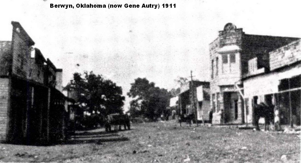
1911 – Berwyn (now Gene Autry) Oklahoma
https://oklahomahistory.net/ttphotos22a/BerwynOklahoma1911.jpg
Sometimes things slip by me. I just learned of my OHP friend, Roy Rogers, passing away in February of covid. Back in the 80s, maybe 70s, on Thanksgiving Day Roy was going deer hunting early that morning east of Ardmore. It was barely getting light out. He was in his pickup and just topped Caldwell Hill east of Ardmore that morning. There in the middle of the road, completely blocking the road crossways, was a pickup pulling a cattle trailer on Highway 199 East. He couldn’t stop and collided with the pickup and trailer driven by Ardmoreite Lewis Nievar. Nievar was trying to turn around on the highway. Roy suffered broken ribs from hitting the steering wheel. As we put him in the ambulance, he looked at me and said, “And he had the nerve to ask me if I had my lights on.”
Rest in peace my friend.https://www.findagrave.com/memorial/236646603/roy-william-rogers
I saw on the national news yesterday where cyber attacks from Russia may be increasing now. If you fear a cyber attack from a foreign website or whatever, I highly recommend you changing your computer’s DNS numbers to OpenDNS. OpenDNS is a free service that automatically protects your computer from tens of thousands of questionable and harmful websites worldwide BEFORE they can reach your computer. You don’t download and install any program on your computer. You only change the 2 DNS numbers in the LOCAL AREA NETWORK CONNECTION in your computer’s settings. The setting is in the TCP/IP SETTING. They have easy to follow directions and help videos on their website. This is truly a must have service along with your antivirus program and spyware/malware program. If you are afraid to delve in to changing your DNS settings (usually in your router), I can probably help you since I’ve been doing it for decades. Just holler at me. By the way, only PCs and laptops, not cellphones.
The conversion of my 26 year old HTML website to my new WordPress website is coming along nicely with more links added the past few days. The link below is a temporary link but you can get an idea how it will look. Nearly all of the individual newsletters (1,300+) has been converted to WordPress.
http://new.oklahomahistory.net/
The link below will give an up-to-date accounting of the donations received and spent so far. Just scroll to the bottom of the webpage.
https://oklahomahistory.net/gofundme
Still finding people in Oklahoma with unclaimed money. We’re now over the $1,834,000 dollars. Sometimes progress is slow locating people or their kin with unclaimed insurance money at the State Treasurers office in OKC but we keep trying.
How long has it been since you checked your name or a family member’s name? Its easy to do a search at the Oklahoma State Treasurer link below. I think every state in the union has a unclaimed property website through the respective state treasures website.
https://apps.ok.gov/unclaimed/If you have Facebook, I created a new Page called Southern Oklahoma Unclaimed Insurance Money. The only Post that will go on that page are names and towns of people we are looking for with unclaimed money;
https://www.facebook.com/South-Central-Oklahoma-Unclaimed-Insurance-Money-114246471027358
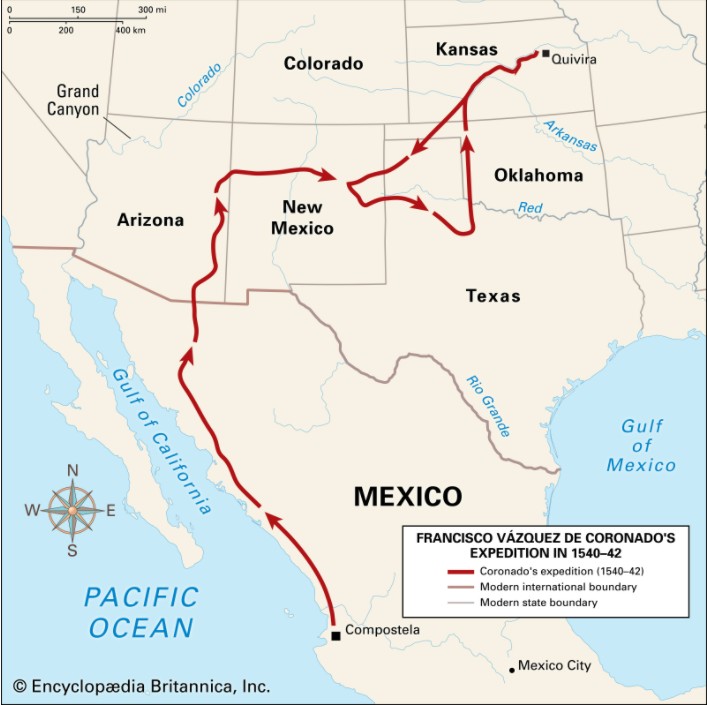
Q. When did Coronado pass through Oklahoma?
A. In April of 1541, the Spanish leader set out in a northeastward trek that took him into the Oklahoma panhandle. Here Coronado’s men found a treeless stretch of land without a single distinguishing feature to serve as a guiding landmark. His march traversed what is now Kansas and the Oklahoma Panhandle, passing near the present communities of Liberal, Kansas, and Tyrone, Hooker, Optima, Guymon, Goodwell, and Texhoma, Oklahoma.
https://oklahomahistory.net/maps/FransicoCoronadoRouteOklahoma.jpgQ. Where is the oldest and largest state park in Oklahoma located?
A. Answer in next week’s newsletterSome mail from this week’s MAILBAG…..
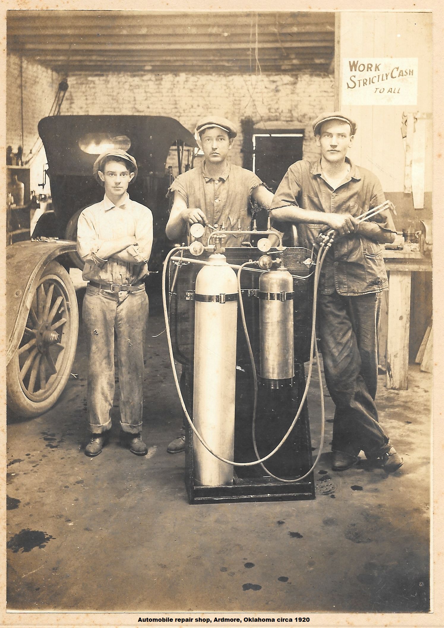
An Ardmore automobile repair shop circa 1920 -Robert Hensley
https://oklahomahistory.net/ttphotos22a/AutomobileRepairShopArdmoreCirca1920.jpg
———————————————————-
———————————————————-
———————————————————-Below is from This and That newsletter archives of March 25, 2010
“Butch; The Buffalo Ranch in Afton, Oklahoma is still in business, but not the same as in the past. It is now a modern convenience store named Buffalo Ranch Travel Plaza, but they still have live buffalo in a field behind the store. I passed by there a few weeks ago. I didn’t stop, but imagine they still have buffalo burgers and tourist stuff for sale. It’s off the beaten path these days with the opening of the Will Rogers turnpike. The convenience store is at on Highway 59-60-69. Route 66 is nonexistent there any longer. The store is located where 60 & 69 “Y” off from highway 59. It’s nothing like what I remember when I was a child and we stopped by the Buffalo Ranch. My first sight of a real buffalo and my first taste of a buffalo burger.
The best buffalo burger these days is found at the Rock Cafe in Stroud. This is also on Route 66. The cafe has been there as long as Route 66. The rocks that were used on the building were dug up as they laid the road bed for Route 66. The Rock Cafe burned a couple of years ago, but the rock walls stood and it was quickly rebuilt. It is still a landmark for those traveling the Mother Road. It’s definitely worth the time to stop, drink a cold bottle of pop, eat a buffalo burger and rest a bit before continuing your journey. It’s a favorite spot of Michael Wallis. You never know who you’ll see there or what country they are from. Summer is always a good time to stop. Lots of folks from around the world come to explore Route 66 and stop by the Rock Cafe.” -Gerald Whitworth
Here’s a link to the blog about the Rock Cafe and its rebirth —
http://rockcafert66.wordpress.com/
—————————————————–
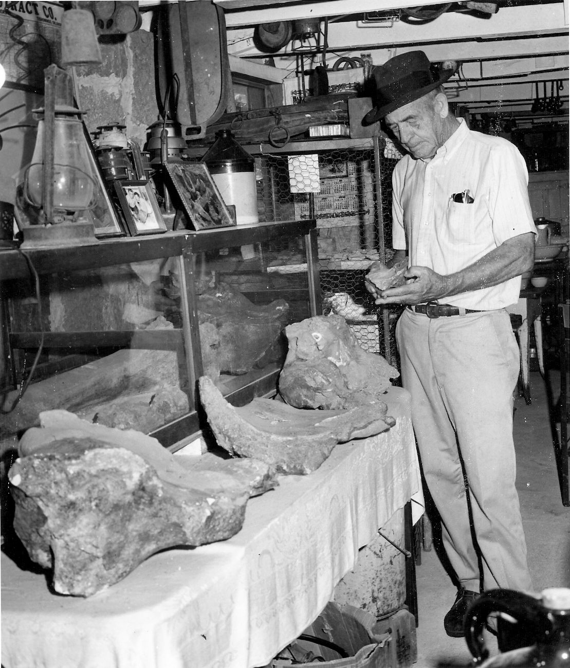
“Butch, The man handling the bones is a Mr. Oscar Garrison who worked for years for the Soil Conservation District in Johnston Co. He had a fabulous arrow head museum located about 1/2 mile west of the Murray State Campus. The bones he is looking at came from about 2 miles North of Russett from an area where there was a pond being dug. He found them in the area where the equipment was digging. He told me there is a complete dinosaur there. He also told me he notified the O.U. Archeology Dept. but they expressed no interest. He had hundreds of arrowheads that he had found and he took pride in the fact that all of them were genuine. About 30 years ago he related to me that a “flint napper” came by to look at his collection and told him that he could chip and arrow head. He offered to show Mr. Garrison how it was done and Mr. Garrison said he gave him a piece of flint and in just a little while he hand him an arrow head that was as perfect as anything in the museum. He said not too long after that a family came by to visit the museum and the little boy asked his Dad to buy him one of the arrowheads. When the father explained to the child that the arrow heads were not for sale, Mr. Garrison told him he had one he could have. He said he gave him the one the flint napper made because he didn’t want it on the place for fear it could some how get mixed up with his original arrow heads. If you will go to Google maps and pull up the intersection of Greasy Bend Rd. & Highway #1 West of Ravia. Look North up the fence line and you will see two ponds that look like they connect. The bones were found on the East side of the bigger pond.Mr. Oscar Garrison died in 1988 when he was up in his 80’s. He has a granddaughter who lives in Tishomingo and I talked to her this afternoon. Her name is Evelen (Mrs. Keavin) Troutman. The dinosaur bones were given to the Ardmore Museum and as far as she knows were never displayed. The one big bone that looks like a 5 foot long chicken thigh bone is now at the Tuckers Tower at Lake Murray with no information as to where it came from etc. She doesn’t know how it got from the Ardmore museum to the Tuckers Tower. Mr. Garrison found the bones some time in the early 1960’s.” -Wendyle Andrews
https://oklahomahistory.net/ttphotos10a/MysteryPhoto2010b.jpg
—————————————————–
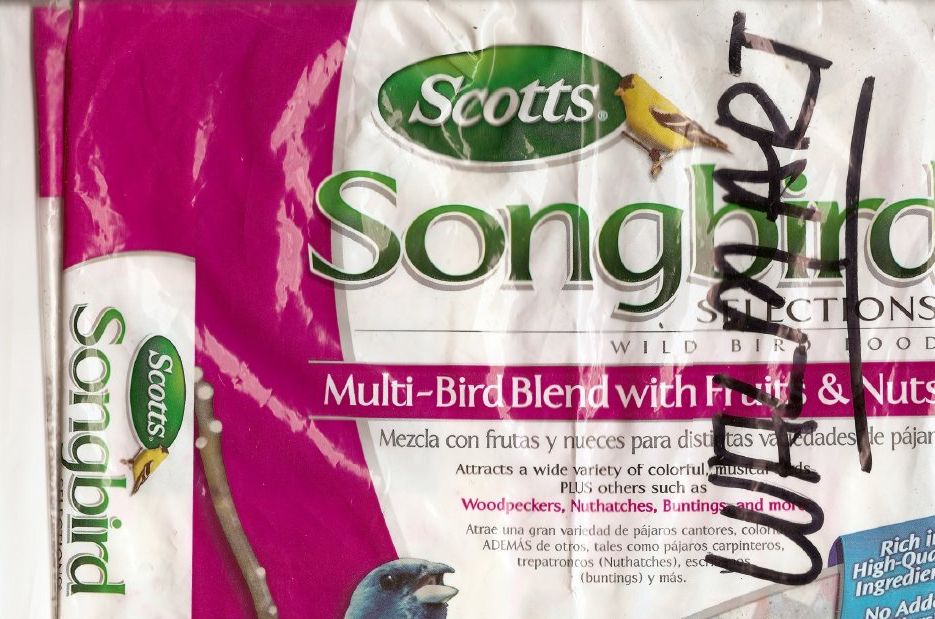
“Hi Butch, It’s quickly approaching time for wild birds to be migrating through your area. Pull out your bird feeders and get them cleaned up and hung outside in areas where they can be easily observed. I have attached a pic of a good wild bird seed that you can get at Wal-Mart. It has a good mix of seeds and fruit and nuts. It should attract the seed eaters, the fruit eater, and of course the nut eaters. We do not have squirrels to contend with here in the Rio Grande Valley so maybe you need feeders that are squirrel proof ???? And while you are at it.. get some hummingbird feeders. Do not buy the hummingbird nectar. It’s simple to make. 1/4th cup sugar to 1 Cup of water. Make up a batch in the microwave put about a cup in each feeder and store the extra in the refrigerator. If you put out too much it will spoil. It won’t be long before you will need a better bird book than what I gave you. and, oh, the sparrows are the first to spot the feeders. they are the “finders”. Don’t worry if they hog the feed, sooner or later you will see all sorts of birds at your feeders and at your chicken feeders, as well. Enjoy, spring is on it’s way.” -Nancy
https://oklahomahistory.net/ttphotos10a/ScottsBirdFeed.jpg
—————————————————–
—————————————————–Mad as a hatter
What mad as a hatter actually refers to is the effects of mercury poisoning, one of which is insanity. Mercury was used in the manufacture of felt hats and hatters, or milliners, often ended up suffering from excessive exposure to it. In the 18th and 19th centuries, industrial workers used a toxic substance, mercury nitrate, as part of the process of turning the fur of small animals, such as rabbits, into felt for hats.See everyone next week!
Butch and Jill Bridges
“Friends Make Life Worth Living”Ardmore, Oklahoma
Vicious Dog Attacks in Oklahoma
https://oklahomahistory.net/viciousdogs.html
Oklahoma Bells: https://oklahomahistory.net/bellpage.html
Bill Hamm’s Cemetery Database
http://www.usgwarchives.net/ok/carter/cartercm.htm
American Flyers Memorial Fund – Administration Webpage
https://oklahomahistory.net/crash66.html
Ardmore Army Air Field/Ardmore Air Force Website
https://oklahomahistory.net/airbase/
Carter County Government Website
http://cartercountyok.us
All previous issues of This & That can be found on my Website’s archives.
Feel free to forward this free newsletter. Mailouts: over 1,300.
To be removed from my T&T mailings, just send me an email.
I do not sell, trade or give my mailing list to anyone for any reason.